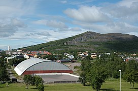
Luossavaara
Appearance
| Luossavaara | |
|---|---|
 | |
| Highest point | |
| Elevation | 724 m (2,375 ft) |
| Coordinates | 67°52′30″N 20°13′20″E / 67.87500°N 20.22222°E |
| Geography | |
 | |
| Location | Kiruna, Sweden |
Luossavaara (Northern Sami: Luossavárri) is a mountain in Kiruna, Sweden. It is the site of a now-inactive iron ore mine formerly operated by the Swedish mining company LKAB. Today it has a ski lift and slope, as well as a hiking path called Midnattsolstigen (the Midnight Sun Trail).
See also
[edit]External links
[edit]- Kiruna ski slope – Information from Kiruna community (Swedish)
- Town hill Luossavaara – Information from Kirunawinter (Swedish)
