Loughtee Upper
Loughtee Upper
Lucht Tí Uachtarach (Irish) | |
|---|---|
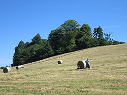
 Hayfield near Cavan Town | |
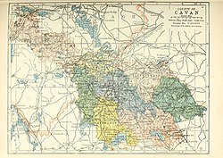
 Barony map of County Cavan, 1900; Loughtee Upper is in the centre, coloured blue. | |
| Coordinates: 54°0′N 7°18′W / 54.000°N 7.300°W | |
| Sovereign state | Ireland |
| Province | Ulster |
| County | Cavan |
| Area | |
• Total | 258.36 km2 (99.75 sq mi) |
Loughtee Upper (Irish: Lucht Tí Uachtarach), or Upper Loughtee, is a barony in County Cavan, Ireland.[1][2] Baronies were mainly cadastral rather than administrative units. They acquired modest local taxation and spending functions in the 19th century before being superseded by the Local Government (Ireland) Act 1898.[3]
Etymology
[edit]Loughtee Upper takes its name from the Irish Lucht Tí, Early Modern Irish lucht tighe Még Mathghamhna (Annals of the Four Masters), "people of the household of Mac Mahon"; the land was allocated to the Mic Bhradaigh vassals of the McMahons as mensal land.[4][5][6][7][8]
Geography
[edit]Loughtee Upper is located in the middle of County Cavan, east of the River Erne and Lough Oughter.[9]
History
[edit]
Loughtee Upper was a centre of power for the Ó Raghallaigh (O'Reillys) Gaelic Irish tribe in the Middle Ages, based first at Lough Oughter and then moving to Tullymongan near to modern Cavan. The MacGobhains (McGowans) served as leader of the gallowglass. A Mic Bradaigh (Brady) family of clerics and freeholders was also here, ruling areas called Cúl Brighde and Teallach Cerbaill, near modern Stradone.[10][11][4]
The barony of Loughtee was created by 1609 in the Plantation of Ulster, and was archaically spelled Loughty.[12] Its alluvial soil was recognised as the best in Cavan, and it was originally allocated to the Crown, then later to undertakers.[13]
It was split into Upper and Lower parts in 1821.[14]
List of settlements
[edit]Below is a list of settlements in Loughtee Upper:
References
[edit]- ^ Riain, Pádraig Ó (7 March 1985). Corpus genealogiarum sanctorum Hiberniae. Dublin Institute for Advanced Studies. ISBN 9780901282804 – via Google Books.
- ^ "DENN, a parish - Topographical Dictionary of Ireland (1837)". www.libraryireland.com.
- ^ General Register Office of Ireland (1904). "Alphabetical index to the baronies of Ireland". Census of Ireland 1901: General topographical index. Command papers. Vol. Cd. 2071. HMSO. pp. 966–978.
- ^ a b FitzPatrick, Elizabeth (7 March 2004). Royal Inauguration in Gaelic Ireland C. 1100-1600: A Cultural Landscape Study. Boydell Press. ISBN 9781843830900 – via Google Books.
- ^ "Lucht Tí Uachtarach/Loughtee Upper". Logainm.ie.
- ^ "Part 3 of Annals of the Four Masters". celt.ucc.ie.
- ^ "Part 3 of Annals of the Four Masters". celt.ucc.ie.
- ^ MacCotter, Paul (7 March 2008). Medieval Ireland: Territorial, Political and Economic Divisions. Four Courts Press. ISBN 9781846820984 – via Google Books.
- ^ http://www.public-library.uk/dailyebook/Atlas%20and%20cyclopedia%20of%20Ireland%20Volume%201%20(1905).pdf [bare URL PDF]
- ^ Quinn, Sean E. (7 March 2000). Surnames in Ireland. Irish Genealogy Press. ISBN 9781871509397 – via Google Books.
- ^ "The Baronies of Ireland - History". sites.rootsweb.com.
- ^ Inquisitionum in officio rotulorum cancellariae Hiberniae asservatarum, repertorium ...: Printed by command of His Majesty King George IV. In pursuance of an address of the House of commons of Great Britain.
- ^ http://mural.maynoothuniversity.ie/1627/1/PDuffyCavan.pdf [bare URL PDF]
- ^ "Census 1821 - County Cavan, IrelandGenWeb". sites.google.com.


