Longtou Township
Appearance
Longtou
龙头乡 | |
|---|---|
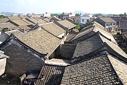
 Ancient Town in Longtou township | |
 | |
| Coordinates: 22°41′51″N 107°57′24″E / 22.69750°N 107.95667°E | |
| Country | People's Republic of China |
| Region | Guangxi |
| Prefecture-level city | Chongzuo |
| County | Fusui |
| Village-level divisions | 1 residential communities 8 villages |
| Area | |
• Total | 179.75 km2 (69.40 sq mi) |
| Population (2011) | |
• Total | 32,000 |
| • Density | 180/km2 (460/sq mi) |
| Time zone | UTC+8 (China Standard) |
| Postal code | 532101 |
Longtou (simplified Chinese: 龙头乡; traditional Chinese: 龍頭鄉; pinyin: Lóngtóu Xiāng; zhuang: Lungzdouz Yangh) is a Township under the administration of Fusui County in southern Guangxi Zhuang Autonomous Region, China.[1] As of 2011[update], it had an area of 179.75 square kilometres (69.40 sq mi) populated by 32,000 people residing in 1 residential communities (社区) and 8 villages.[2]
Administrative divisions
[edit]There are 1 residential communities and 8 villages:[3]
Residential communities:
- Longtou(龙头社区)
Villages:
- Tengguang(滕广村), Jiuzhuang(旧庄村), Fengzhuang(凤庄村), Xiaohan( 肖汉村), Natang(那塘村), Tanlong(坛龙村), Nagui(那贵村), Linwang(林旺村)
See also
[edit]References
[edit]- ^ 2011年统计用区划代码和城乡划分代码:扶绥县 (in Chinese). National Bureau of Statistics of the People's Republic of China. Archived from the original on 2012-07-21. Retrieved 2013-01-08.
- ^ 2011年统计用区划代码和城乡划分代码:龙头乡 (in Chinese). National Bureau of Statistics of the People's Republic of China. Archived from the original on February 19, 2013. Retrieved 2013-01-03.
- ^ 2011年统计用区划代码和城乡划分代码:龙头乡 中华人民共和国国家统计局 National Bureau of Statistics of the People's Republic of China. Retrieved 2013-01-02.(in Chinese)
External links
[edit]- Longtou Township/Official website of Longtou(in Chinese)
