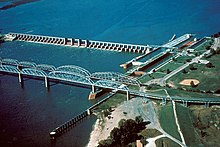
Lock and Dam No. 26 (historical)
Appearance
| Lock and Dam No. 26 | |
|---|---|
 Old Lock and Dam 26 and the Old Clark Bridge with a swing span rail bridge in between. | |
| Country | USA |
| Location | Alton, Illinois |
| Coordinates | 38°53′10″N 90°10′55″W / 38.88611°N 90.18194°W |
| Status | Decommissioned |
| Construction began | 1939 |
| Demolition date | 1990 |
| Dam and spillways | |
| Impounds | Upper Mississippi River |
| Length | 600 ft |
Lock and Dam No. 26 was a lock and dam located near Alton, Illinois on the Upper Mississippi River around river mile 202.5.
Opened in 1938, its largest lock was 600 feet long. It was demolished in 1990 and replaced by the Melvin Price Locks and Dam, which is also known as Lock and Dam number 26.
See also
[edit]External links
[edit]- Historic American Engineering Record (HAER) No. IL-31, "Upper Mississippi River 9-Foot Channel Project, Lock and Dam 26" includes photos of the lock and dam, the old Clark Bridge, and the adjacent swing span rail bridge.
38°53′10″N 90°10′55″W / 38.88611°N 90.18194°W
Categories:
- Buildings and structures in Madison County, Illinois
- Mississippi River locks
- Buildings and structures in St. Charles County, Missouri
- Dams in Missouri
- Dams in Illinois
- United States Army Corps of Engineers dams
- Transport infrastructure completed in 1938
- Historic American Engineering Record in Illinois
- Historic American Engineering Record in Missouri
- Transportation buildings and structures in Madison County, Illinois
- Water transport stubs
