Loch of Lintrathen
| Loch of Lintrathen | |
|---|---|
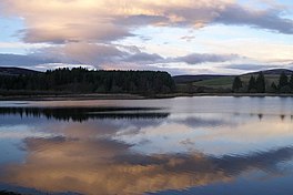
 Loch of Lintrathen at dusk | |
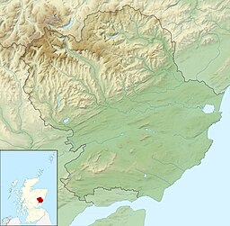
| Location | NO27765487 |
| Coordinates | 56°40′49″N 3°10′58″W / 56.68030167°N 3.18285226°W |
| Type | freshwater loch |
| Max. length | 2 km (1.2 mi)[1] |
| Max. width | 1.2 km (0.75 mi)[1] |
| Surface area | 169 ha (420 acres)[2] |
| Average depth | 23.29 ft (7.10 m)[1] |
| Max. depth | 69.88 ft (21.30 m)[1] |
| Water volume | 423,213,862 cu ft (11,984,082.0 m3)[1] |
| Shore length1 | 8 km (5.0 mi) [2] |
| Surface elevation | 205 m (673 ft)[2] |
| Max. temperature | 55.5 °F (13.1 °C) |
| Min. temperature | 48.0 °F (8.9 °C) |
| Islands | 0 |
| Settlements | Kirriemuir |
| 1 Shore length is not a well-defined measure. | |
Loch of Lintrathen is a man-made loch occupying a glacial basin at the southern end of Glen Isla,[3] approximately 13 kilometres (8.1 miles) west of town of Kirriemuir in Angus, Scotland.[1][2]
The small village of Bridgend of Lintrathen lies on the southern shore of the loch, which is owned by Scottish Water and used as a water supply reservoir as well as an important wildlife site.[4] The loch has been the main water supply for the city of Dundee and Angus since 1875.[5] The water in the Loch of Lintrathen feeds down from Backwater Reservoir 4 kilometres (2.5 miles) to the north and exits it via sluices at Bridgend of Lintrathen, flowing southward past Lintrathen Mill in the ‘Melgam Water’, which has a confluence with the River Isla 3 kilometres (1.9 miles) farther south at Airlie Castle.[6] The loch has a surface area of 151.1 hectares (373 acres) and its dam is an earthworks dam.[3]
Loch of Lintrathen is a mid-altitude oligotrophic-mesotrophic loch, which supports large numbers of birds. There are internationally important numbers of greylag geese, with 3% of the Iceland population over-wintering at the site.[7] Other wildlife includes whooper swans, otters and osprey, and the loch is used for trout fishing.[4] The fishing is managed by the Lintrathen Angling Club and both brown and rainbow trout are fished for.[3]
As well as being recognised as a wetland of international importance under the Ramsar Convention,[8] Loch of Lintrathen has also been designated a Special Protection Area and a Site of Special Scientific Interest.[9] The Ramsar Site includes an area of marshland in the north-west, a total of 217 hectares being protected.[8] The loch and surrounding area is also maintained as a nature reserve by the Scottish Wildlife Trust.[4]
References
[edit]- ^ a b c d e f John, Murray; Lawrence, Pullar. Bathymetrical Survey of the Fresh-Water Lochs of Scotland, 1897–1909 Lochs of the Tay Basin Volume II – Loch of Lintrathen. National Library of Scotland. p. 122. Retrieved 6 December 2020.
 This article incorporates text from this source, which is in the public domain.
- ^ a b c d "Loch of Lintrathen". Centre for Ecology and Hydrology. Scotland and Northern Ireland Forum for Environmental Research (SNIFFER). Retrieved 6 December 2020.
- ^ a b c "Lintrathen, Loch of". Gazetteer for Scotland. Retrieved 5 March 2020.
- ^ a b c "Loch of Lintrathen". Scottish Wildlife Trust. Retrieved 12 April 2019.,
- ^ "Loch Of Lintrathen Reservoir, Dam". Historic Environment Scotland. Retrieved 5 March 2020.
- ^ "Loch of Lintrathen Wildlife Reserve". Cateran Museum. Retrieved 5 March 2020.
- ^ "UK Loch of Lintrathen 13039 RIS 2006" (PDF). Ramsar Sites Information Service. Retrieved 12 April 2019.
- ^ a b "Loch of Lintrathen". Ramsar Sites Information Service. Retrieved 12 April 2019.
- ^ "Loch of Lintrathen SPA". Joint Nature Conservation Committee. Retrieved 12 April 2019.

