Llechog
Appearance
| Llechog | |
|---|---|
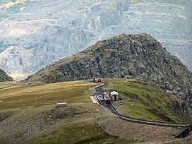
 Llechog from Garnedd Ugain, with Clogwyn Station in front | |
| Highest point | |
| Elevation | 720 m (2,360 ft) |
| Prominence | 28 m (92 ft) |
| Parent peak | Snowdon |
| Listing | sub Hewitt, Nuttall |
| Coordinates | 53°04′30″N 4°04′35″W / 53.07499°N 4.07633°W |
| Naming | |
| English translation | slaty, rocky, stony |
| Language of name | Welsh |
| Geography | |
Gwynedd, Wales | |
| Parent range | Snowdonia |
| OS grid | SH610551 |
| Topo map | OS Landranger 115 |
Llechog is a top of Garnedd Ugain on the Snowdon massif in Wales. It is the top of a long crest of cliffs that start in Llanberis and finishes on Garnedd Ugain. The nearby Clogwyn Station is a stop of the Snowdon mountain railway. The summit is a rocky peak sitting out from cliffs which fall steeply down to the Nant Peris valley. The viewpoint is commanding, where the full prominence of Glyder Fawr, Y Garn, Elidir Fawr and Crib Goch can be admired.[1]
A second top of the same name can also be found about 1/2 mile to the south-west of Snowdon summit, overlooking Cwm Clogwyn.
References
[edit]- ^ Nuttall, John & Anne (1999). The Mountains of England & Wales - Volume 1: Wales (2nd edition ed.). Milnthorpe, Cumbria: Cicerone. ISBN 1-85284-304-7.

