Ljungan
Appearance
You can help expand this article with text translated from the corresponding article in Swedish. (March 2022) Click [show] for important translation instructions.
|
| Ljungan | |
|---|---|
 | |
 | |
| Location | |
| Country | Sweden |
| Physical characteristics | |
| Mouth | Bothnian Sea |
• coordinates | 62°19′N 17°23′E / 62.317°N 17.383°E |
• elevation | 0 m (0 ft) |
| Length | 350 km (220 mi)[1] |
| Basin size | 12,851.1 km2 (4,961.8 sq mi)[2] |
| Discharge | |
| • average | 140 m3/s (4,900 cu ft/s)[1] |
| • maximum | 850 m3/s (30,000 cu ft/s)[1] |
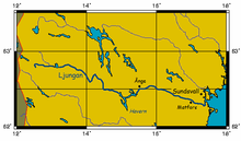
Ljungan (Jamtlandic: Jångna or Aoa, from Old Norse *Oghn "the dreadful"[3]) is a 322 kilometer long river in Sweden. It originates near Trondheim and the Norwegian border. The river runs through the Swedish counties of Jämtland and Västernorrland. Several hydropower plants are located along the river.
A pathogenic virus of the viral family which includes polio and hepatitis A was isolated from a bank vole near the Ljungan river in the mid-1990s, and named Ljungan virus.
Some towns near or by the river are:
References
[edit]- ^ a b c "Ljungan". Nationalencyklopedin (in Swedish). Retrieved 14 July 2010. (subscription required)
- ^ "Län och huvudavrinningsområden i Sverige" (PDF) (in Swedish). Swedish Meteorological and Hydrological Institute. Retrieved 14 July 2010.
- ^ Hellquist, Elof (1922). Svensk etymologisk ordbok. Stockholm: Gleerups förlag. p. 416.
