Jump to content

List of airports in Nunavut

From Wikipedia, the free encyclopedia

Nunavut

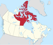
This is a list of airports in Nunavut. It includes all Nav Canada certified and registered water and land airports, aerodromes and heliports in the Canadian territory of Nunavut.[1][2] Airport names in italics are part of the National Airports System.[3] With the exception of Iqaluit and Sanikiluaq airports, all other airports in Nunavut are within the Northern Domestic Airspace.

List of airports and heliports

[edit]
Pangnirtung Airport
Kugluktuk Airport
Kugaaruk Airport
Grise Fiord Airport
Cambridge Bay Airport
Arctic Bay Airport

The list is sorted by the name of the community served; click the sort buttons in the table header to switch listing order.

Community   Airport name   ICAO   TC LID   IATA   Coordinates  
Alert Alert Airport CYLT YLT 82°31′04″N 062°16′50″W / 82.51778°N 62.28056°W / 82.51778; -62.28056 (Alert Airport)
Arctic Bay Arctic Bay Airport CYAB YAB 73°00′19″N 085°01′59″W / 73.00528°N 85.03306°W / 73.00528; -85.03306 (Arctic Bay Airport)
Arviat Arviat Airport CYEK YEK 61°05′39″N 094°04′15″W / 61.09417°N 94.07083°W / 61.09417; -94.07083 (Arviat Airport)
Arviat Arviat Water Aerodrome CRV8 61°08′50″N 094°06′57″W / 61.14722°N 94.11583°W / 61.14722; -94.11583 (Arviat Water Aerodrome)
Baker Lake Baker Lake Airport CYBK YBK 64°17′56″N 096°04′40″W / 64.29889°N 96.07778°W / 64.29889; -96.07778 (Baker Lake Airport)
Baker Lake Baker Lake Water Aerodrome CJK6 64°19′00″N 096°01′00″W / 64.31667°N 96.01667°W / 64.31667; -96.01667 (Baker Lake Water Aerodrome)
Cambridge Bay Cambridge Bay Airport CYCB YCB 69°06′29″N 105°08′18″W / 69.10806°N 105.13833°W / 69.10806; -105.13833 (Cambridge Bay Airport)
Cambridge Bay Cambridge Bay Water Aerodrome CJD7 69°07′20″N 105°01′15″W / 69.12222°N 105.02083°W / 69.12222; -105.02083 (Cambridge Bay Water Aerodrome)
Chesterfield Inlet Chesterfield Inlet Airport CYCS YCS 63°20′50″N 090°43′52″W / 63.34722°N 90.73111°W / 63.34722; -90.73111 (Chesterfield Inlet Airport)
Clyde River Clyde River Airport CYCY YCY 70°29′10″N 068°31′00″W / 70.48611°N 68.51667°W / 70.48611; -68.51667 (Clyde River Airport)
Coral Harbour Coral Harbour Airport CYZS YZS 64°11′36″N 083°21′34″W / 64.19333°N 83.35944°W / 64.19333; -83.35944 (Coral Harbour Airport)
Eureka Eureka Aerodrome CYEU YEU 79°59′40″N 085°48′43″W / 79.99444°N 85.81194°W / 79.99444; -85.81194 (Eureka Airport)
George Lake George Lake Aerodrome CGR3 65°55′43″N 107°27′45″W / 65.92861°N 107.46250°W / 65.92861; -107.46250 (George Lake Aerodrome)
Gjoa Haven Gjoa Haven Airport CYHK YHK 68°38′08″N 095°51′01″W / 68.63556°N 95.85028°W / 68.63556; -95.85028 (Gjoa Haven Airport)
Goose Lake Goose Lake Aerodrome CGS2 65°33′07″N 106°26′09″W / 65.55194°N 106.43583°W / 65.55194; -106.43583 (Goose Lake Aerodrome)
Grise Fiord Grise Fiord Airport CYGZ YGZ 76°25′33″N 082°54′29″W / 76.42583°N 82.90806°W / 76.42583; -82.90806 (Grise Fiord Airport)
Hope Bay Hope Bay Aerodrome CHB3 UZM 68°09′40″N 106°36′56″W / 68.16111°N 106.61556°W / 68.16111; -106.61556 (Hope Bay Aerodrome)
Igloolik Igloolik Airport CYGT YGT 69°21′53″N 081°48′58″W / 69.36472°N 81.81611°W / 69.36472; -81.81611 (Igloolik Airport)
Iqaluit Iqaluit Airport CYFB YFB 63°45′23″N 068°33′21″W / 63.75639°N 68.55583°W / 63.75639; -68.55583 (Iqaluit Airport)
Kimmirut Kimmirut Airport CYLC YLC 62°51′00″N 069°53′00″W / 62.85000°N 69.88333°W / 62.85000; -69.88333 (Kimmirut Airport)
Kinngait Cape Dorset Airport CYTE YTE 64°13′49″N 076°31′29″W / 64.23028°N 76.52472°W / 64.23028; -76.52472 (Cape Dorset Airport)
Kugaaruk Kugaaruk Airport CYBB YBB 68°32′04″N 089°48′29″W / 68.53444°N 89.80806°W / 68.53444; -89.80806 (Kugaaruk Airport)
Kugluktuk Kugluktuk Airport CYCO YCO 67°49′00″N 115°08′38″W / 67.81667°N 115.14389°W / 67.81667; -115.14389 (Kugluktuk Airport)
Mary River Mary River Aerodrome CMR2 YMV 71°19′25″N 079°21′14″W / 71.32361°N 79.35389°W / 71.32361; -79.35389 (Mary River Aerodrome)
Meadowbank Gold Mine Meadowbank Aerodrome CMB2 65°01′30″N 096°04′16″W / 65.02500°N 96.07111°W / 65.02500; -96.07111 (Meadowbank Aerodrome)
Naujaat Naujaat Airport CYUT YUT 66°31′17″N 086°13′29″W / 66.52139°N 86.22472°W / 66.52139; -86.22472 (Repulse Bay Airport)
Pangnirtung Pangnirtung Airport CYXP YXP 66°08′42″N 065°42′49″W / 66.14500°N 65.71361°W / 66.14500; -65.71361 (Pangnirtung Airport)
Pond Inlet Pond Inlet Airport CYIO YIO 72°41′22″N 077°58′08″W / 72.68944°N 77.96889°W / 72.68944; -77.96889 (Pond Inlet Airport)
Qikiqtarjuaq Qikiqtarjuaq Airport CYVM YVM 67°32′45″N 064°01′53″W / 67.54583°N 64.03139°W / 67.54583; -64.03139 (Qikiqtarjuaq Airport)
Rankin Inlet Rankin Inlet Airport CYRT YRT 62°48′41″N 092°06′57″W / 62.81139°N 92.11583°W / 62.81139; -92.11583 (Rankin Inlet Airport)
Resolute Resolute Bay Airport CYRB YRB 74°43′01″N 094°58′10″W / 74.71694°N 94.96944°W / 74.71694; -94.96944 (Resolute Bay Airport)
Sandspit Lake Hayes Camp Aerodrome CHC5 68°39′20″N 091°32′42″W / 68.65556°N 91.54500°W / 68.65556; -91.54500 (Hayes Camp Aerodrome)
Sanikiluaq Sanikiluaq Airport CYSK YSK 56°32′13″N 079°15′00″W / 56.53694°N 79.25000°W / 56.53694; -79.25000 (Sanikiluaq Airport)
Sanirajak Hall Beach Airport CYUX YUX 68°46′32″N 081°14′40″W / 68.77556°N 81.24444°W / 68.77556; -81.24444 (Hall Beach Airport)
Somerset Island Arctic Watch Lodge Aerodrome CRW4 74°04′05″N 093°47′05″W / 74.06806°N 93.78472°W / 74.06806; -93.78472 (Arctic Watch Lodge Aerodrome)
Taloyoak Taloyoak Airport CYYH YYH 69°32′48″N 093°34′37″W / 69.54667°N 93.57694°W / 69.54667; -93.57694 (Taloyoak Airport)
Tanquary Fiord Tanquary Fiord Airport CJQ6 JQ6 81°24′34″N 076°52′54″W / 81.40944°N 76.88167°W / 81.40944; -76.88167 (Tanquary Fiord Airport)
Whale Cove Whale Cove Airport CYXN YXN 62°14′24″N 092°35′53″W / 62.24000°N 92.59806°W / 62.24000; -92.59806 (Whale Cove Airport)

Defunct airports

[edit]
Community   Airport name   ICAO   TC LID   IATA   Coordinates  
Doris Lake Doris Lake Aerodrome CDL7 JOJ 68°07′31″N 106°35′07″W / 68.12528°N 106.58528°W / 68.12528; -106.58528 (Doris Lake Aerodrome)
Iqaluit Frobisher Bay Air Base 63°45′21″N 068°32′23″W / 63.75583°N 68.53972°W / 63.75583; -68.53972 (Lupin Mine Airport (abandoned))
Lupin Mine Lupin Airport CYWO YWO 65°45′33″N 111°15′00″W / 65.75917°N 111.25000°W / 65.75917; -111.25000 (Lupin Mine Airport (abandoned))
Nanisivik Nanisivik Airport CYSR YSR 72°58′56″N 084°36′49″W / 72.98222°N 84.61361°W / 72.98222; -84.61361 (Nanisivik Airport)

References

[edit]
  1. ^ Canada Flight Supplement. Effective 0901Z 16 July 2020 to 0901Z 10 September 2020.
  2. ^ Nav Canada's Water Aerodrome Supplement. Effective 0901Z 26 March 2020 to 0901Z 22 April 2021.
  3. ^ National Airports System