Lipová (Cheb District)
Lipová | |
|---|---|
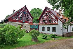
 Folk architecture houses in Doubrava | |
| Coordinates: 50°2′11″N 12°26′56″E / 50.03639°N 12.44889°E | |
| Country | |
| Region | Karlovy Vary |
| District | Cheb |
| First mentioned | 1473 |
| Area | |
• Total | 45.76 km2 (17.67 sq mi) |
| Elevation | 506 m (1,660 ft) |
| Population (2024-01-01)[1] | |
• Total | 729 |
| • Density | 16/km2 (41/sq mi) |
| Time zone | UTC+1 (CET) |
| • Summer (DST) | UTC+2 (CEST) |
| Postal code | 350 02 |
| Website | www |
Lipová (German: Lindenhau) is a municipality and village in Cheb District in the Karlovy Vary Region of the Czech Republic. It has about 700 inhabitants.
Administrative parts
[edit]The villages of Dolní Lažany, Dolní Lipina, Doubrava, Horní Lažany, Mechová, Mýtina, Palič and Stebnice are administrative parts of Lipová.
Geography
[edit]Lipová is located about 6 kilometres (4 mi) southeast of Cheb and 35 km (22 mi) southwest of Karlovy Vary, on the border with Germany. The northern part of the municipality lies in the Cheb Basin. The southern part extends into the Fichtel Mountains and the southeastern part into the Upper Palatine Forest. The highest point is located on the southeastern municipal border, on the slopes of the Dyleň mountain, at 825 m (2,707 ft) above sea level. The northern municipal border is formed by the Jesenice Reservoir, built on the Wondreb river.
Near the village of Mýtina is the Železná hůrka National Nature Monument with an extinct Quaternary volcano.
History
[edit]The first written mention of Lipová is from 1473. In 1960, the municipalities of Lipová, Mýtina and Palič were merged.[2]
Demographics
[edit]
|
|
| ||||||||||||||||||||||||||||||||||||||||||||||||||||||
| Source: Censuses[3][4] | ||||||||||||||||||||||||||||||||||||||||||||||||||||||||
Transport
[edit]Lipová is located on the railway line Plzeň–Karlovy Vary.[5]
Sights
[edit]
The village of Doubrava is a well-preserved set of half-timbered, timbered and brick buildings, dating from the 18th and 19th centuries. They are an example of folk architecture typical for this region. For its value, the village is protected as a village monument reservation.[6] For similar reasons, the village of Dolní Lažany is protected as a village monument zone.[7]
The Church of Saint Anne is located in Palič. It was built in the late Baroque style in 1751–1756. In the following years, it was rebuilt in the Neoclassical style into its present form.[8]
References
[edit]- ^ "Population of Municipalities – 1 January 2024". Czech Statistical Office. 2024-05-17.
- ^ "Historie obce" (in Czech). Obec Lipová. Retrieved 2023-02-13.
- ^ "Historický lexikon obcí České republiky 1869–2011" (in Czech). Czech Statistical Office. 2015-12-21.
- ^ "Population Census 2021: Population by sex". Public Database. Czech Statistical Office. 2021-03-27.
- ^ "Detail stanice Lipová u Chebu" (in Czech). České dráhy. Retrieved 2024-02-13.
- ^ "Doubrava" (in Czech). National Heritage Institute. Retrieved 2024-02-13.
- ^ "Dolní Lažany" (in Czech). National Heritage Institute. Retrieved 2024-02-13.
- ^ "Kostel sv. Anny" (in Czech). National Heritage Institute. Retrieved 2024-02-13.


