Lieveren
Appearance
Lieveren | |
|---|---|
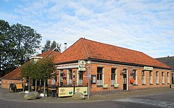
 Pub 't Hart van Lieveren | |
Location in province of Drenthe in the Netherlands | |
| Coordinates: 53°6′55″N 6°27′8″E / 53.11528°N 6.45222°E | |
| Country | Netherlands |
| Province | Drenthe |
| Municipality | Noordenveld |
| Area | |
• Total | 0.24 km2 (0.09 sq mi) |
| Elevation | 4 m (13 ft) |
| Population (2021)[1] | |
• Total | 120 |
| • Density | 500/km2 (1,300/sq mi) |
| Time zone | UTC+1 (CET) |
| • Summer (DST) | UTC+2 (CEST) |
| Postal code | 9304 |
| Dialing code | 050 |
Lieveren is a village in the Netherlands and is part of the Noordenveld municipality in Drenthe.
Lieveren is an esdorp which formed along the Lieverse Diep in the early middle ages.[3] It was first mentioned in 1480 as Tho Liveren. The etymology is unclear.[4] Most of the river has been canalised, however it still meanders through the landscape near Lieveren. In 1840, Lieveren was home to 93 people. The local pub is the only monument of the village.[3]
Gallery
[edit]-
Huize te Lieveren
-
Fish trap near Lieveren
References
[edit]- ^ a b "Kerncijfers wijken en buurten 2021". Central Bureau of Statistics. Retrieved 9 March 2022.
- ^ "Postcodetool for 9304TG". Actueel Hoogtebestand Nederland (in Dutch). Het Waterschapshuis. Retrieved 9 March 2022.
- ^ a b "Lieveren". Plaatsengids (in Dutch). Retrieved 9 March 2022.
- ^ "Lieveren - (geografische naam)". Etymologiebank (in Dutch). Retrieved 9 March 2022.
Wikimedia Commons has media related to Lieveren.


