Leopoldsteinersee
| Leopoldsteinersee | |
|---|---|
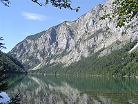
 Looking down from Pfaffenstein towards Leopoldsteiner Lake | |
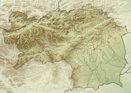
| Coordinates | 47°34′19″N 14°51′41″E / 47.572038°N 14.861473°E |
| Type | Mountain lake |
| Basin countries | Austria |
| Max. length | 1,400 metres (4,600 ft) |
| Max. width | 370 metres (1,210 ft) |
| Max. depth | 31 metres (102 ft) |
| Surface elevation | 628 metres (2,060 ft) |
The Leopoldsteinersee is a mountain lake in Styria, in the east of Austria, about 4 kilometres (2.5 mi) northwest of the city of Eisenerz. The lake is named after the nearby Leopoldstein Castle.
Description
[edit]The Leopoldsteinersee is situated at 628 metres (2,060 ft) above sea level at the foot of the Seemauer in the western Hochschwab range. The lake is 1,400 metres (4,600 ft) long and 370 metres (1,210 ft) wide. The maximum depth is 31 metres (102 ft). The river Seebach feeds the lake, but it is mainly fed by underground springs.[1] The lake is surrounded by rugged mountains with mixed or coniferous forests. A 3 kilometres (1.9 mi) hiking trail circles the lake. There is a local outfit that rents electric or rowing boats.[2]
Legend
[edit]The people near the lake have a legend that a merman was caught in the lake. To buy his freedom he showed his captors the iron deposits at Erzberg. Then he disappeared into the Wassermannsloch.[1]
Gallery
[edit]-
View of Leopoldsteiner See
-
Fishermen on the lake in 1822. Watercolor by Matthäus Loder
-
Looking towards the northwest
-
Lysandra coridon photographed near the lake
References
[edit]Citations
Sources
- "Lake Leopoldsteinersee – a natural treasure". Erzberg Erlebnisregion. Retrieved 2013-12-02.
- "Naturbadesee Leopoldsteinersee". bergfex.com. Retrieved 2013-12-02.


![Fishermen on the lake in 1822. Watercolor by Matthäus Loder [de]](http://upload.wikimedia.org/wikipedia/commons/thumb/8/87/067_Fischer_am_Leopoldsteinersee_-_Aquarell_von_Matth%C3%A4us_Loder%2C_1822.jpg/200px-067_Fischer_am_Leopoldsteinersee_-_Aquarell_von_Matth%C3%A4us_Loder%2C_1822.jpg)

