Leivonmäki National Park
Appearance
(Redirected from Leivonmaeki National Park)
| Leivonmäki National Park | |
|---|---|
 | |
| Location | Central Finland, Finland |
| Coordinates | 61°56′N 026°02′E / 61.933°N 26.033°E |
| Area | 29 km2 (11 sq mi) |
| Established | 2003 |
| Visitors | 12500 (in 2009[1]) |
| Governing body | Metsähallitus |
| Website | www |
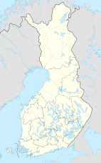
Leivonmäki National Park (Finnish: Leivonmäen kansallispuisto) is a national park in Central Finland. It was established in 2003 and covers 29 square kilometres (11 sq mi).
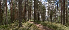
Typical scenery consists of swamps, shores of a medium-sized lake Rutajärvi and esker forests.
Gallery
[edit]
|
See also
[edit]References
[edit]- ^ "Käyntimäärät kansallispuistoittain 2009" (in Finnish). Metsähallitus. Retrieved September 29, 2010.
External links
[edit] Media related to Leivonmäki National Park at Wikimedia Commons
- Outdoors.fi – Leivonmäki National Park


