Leander station
Appearance
Leander | |||||||||||
|---|---|---|---|---|---|---|---|---|---|---|---|
 | |||||||||||
| General information | |||||||||||
| Location | 800 North U.S. Highway 183 Leander, TX | ||||||||||
| Coordinates | 30°35′11″N 97°51′21″W / 30.58639°N 97.85583°W | ||||||||||
| Owned by | CapMetro | ||||||||||
| Platforms | Island | ||||||||||
| Connections | |||||||||||
| Construction | |||||||||||
| Parking | 600+ spaces | ||||||||||
| Accessible | Yes | ||||||||||
| History | |||||||||||
| Opened | March 22, 2010[1] | ||||||||||
| Services | |||||||||||
| |||||||||||
| |||||||||||
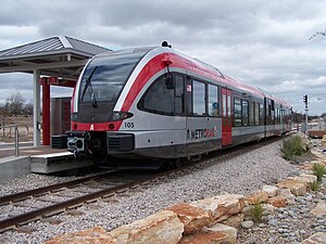
Leander station is a CapMetro Rail hybrid rail station and park and ride in Leander, Texas. The park and ride portion of it, designed by McKinney York Architects, was built in 2007 and is located on Highway 183 just north of FM 2243 and is the northern terminus of the Red Line.[2] Leander station is one of two stations located within Williamson County alongside Lakeline station as opposed to Travis County which contains the other seven locations. Leander station includes a park and ride with 600 spaces.[3]
Bus connections
[edit]- #985 Leander/Lakeline Direct
- #987 Leander/Lakeline Express
References
[edit]- ^ Wear, Ben (March 23, 2010). "MetroRail launches with smooth start". Austin American-Statesman. p. A1.
- ^ "TOD Progress at Leander Station". CapMetro Blog. CapMetro. January 12, 2009. Retrieved December 3, 2010.
- ^ "MetroRail Stations - CapMetro - Austin Public Transit". www.capmetro.org. Archived from the original on January 28, 2015.
External links
[edit]

