Lea River
Appearance
| River Lea | |
|---|---|
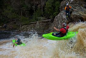
 Dan Hall and Rob Parker boofing First Drop, on their way to winning the 10th anniversary race on the Lea River. | |
| Etymology | River Lea |
| Location | |
| Country | Australia |
| State | Tasmania |
| Region | North-western Tasmania |
| Physical characteristics | |
| Source | |
| • location | Lake Lea |
| • coordinates | 41°30′56″S 145°56′09″E / 41.51556°S 145.93583°E |
| • elevation | 818 m (2,684 ft) |
| Mouth | Lake Gairdner |
• coordinates | 41°28′17″S 146°03′55″E / 41.47139°S 146.06528°E |
• elevation | 472 m (1,549 ft) |
The River Lea is a steep continuous river located in the north-western region of Tasmania, Australia.
The river has an average gradient of 27 metres per kilometre (140 ft/mi) and a peak grade of 45 metres per kilometre (240 ft/mi)[1] that flows from Lake Lea to Lake Gairdner.
The river flows during the Tasmanian winter and spring, with flow reducing over the drier summer months.
Located in a remote wilderness area, the Lea River is the site of the annual Lea Extreme Race.
Named places on the Lea River
[edit]| First Drop | 41°28′25″S 146°02′56″E / 41.47361°S 146.04889°E |
| Dog Leg | |
| Screaming Plastic Surgeons | |
| Proctologists' Twist |
See also
[edit]References
[edit]- ^ "Lea". www.paddletasmania.canoe.org.au. Archived from the original on 27 October 2009.

