Lat Krabang subdistrict
Appearance
Lat Krabang
ลาดกระบัง | |
|---|---|
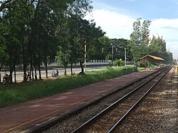
 Phra Chom Klao railway halt, Lat Krabang in late 2022 | |
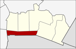
 Location in Lat Krabang District | |
| Country | |
| Province | Bangkok |
| Khet | Lat Krabang |
| Area | |
| • Total | 10.823 km2 (4.179 sq mi) |
| Population (2019) | |
| • Total | 30,353 |
| Time zone | UTC+7 (ICT) |
| Postal code | 10520 |
| TIS 1099 | 101101 |
Lat Krabang (Thai: ลาดกระบัง, pronounced [lâːt krā.bāŋ]) is a khwaeng (subdistrict) of Lat Krabang District, in Bangkok, Thailand. In 2019, it had a total population of 30,353 people.[2]
References
[edit]- ^ Administrative Strategy Division, Strategy and Evaluation Department, Bangkok Metropolitan Administration (2021). สถิติกรุงเทพมหานครประจำปี 2563 [Bangkok Statistics 2020] (PDF) (in Thai). Retrieved 27 November 2021.
{{cite web}}: CS1 maint: multiple names: authors list (link) - ^ "Population statistics 2019" (in Thai). Department of Provincial Administration. Retrieved 2020-10-08.,
13°42′57″N 100°45′07″E / 13.715953°N 100.752059°E
