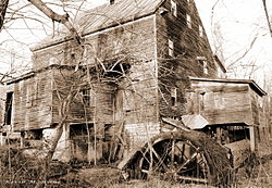
Lantz Mill
Lantz Mill | |
 Lantz Mill in 2005 | |
| Location | 95 Swover Creek Rd., near Edinburg, Virginia |
|---|---|
| Coordinates | 38°50′28″N 78°35′33″W / 38.84111°N 78.59250°W |
| Area | 1 acre (0.40 ha) |
| Built | c. 1867 |
| NRHP reference No. | 07001145[1] |
| VLR No. | 085-0933-0001 |
| Significant dates | |
| Added to NRHP | November 1, 2007 |
| Designated VLR | September 5, 2007[2] |
Lantz Mill, also known as Lantz Roller Mill, is a historic grist mill located at Lantz Mills, near the town of Edinburg in Shenandoah County, Virginia. It was rebuilt in 1865, after being destroyed by Union troops in 1864 during "The Burning", an American Civil War military action conducted by General Philip Sheridan in the Valley Campaigns of 1864. It is a 2+1⁄2-story frame building erected with post-and-beam construction. It sits on an eight foot high limestone foundation and has a steep standing seam metal gable roof. Four additions were made to the mill in the early 20th century. The mill foundation, mill race (contributing), and mill-dam were constructed some time before 1813. The mill closed in the late 1970s.[3]
It was listed on the National Register of Historic Places in 2007.[1]
References
[edit]- ^ a b "National Register Information System". National Register of Historic Places. National Park Service. July 9, 2010.
- ^ "Virginia Landmarks Register". Virginia Department of Historic Resources. Retrieved 5 June 2013.
- ^ Christopher Hernandez-Roy (June 2007). "National Register of Historic Places Inventory/Nomination: Lantz Mill" (PDF). Virginia Department of Historic Resources. and Accompanying four photos
External links
[edit]![]() Media related to Lantz Mill at Wikimedia Commons
Media related to Lantz Mill at Wikimedia Commons
- Grinding mills on the National Register of Historic Places in Virginia
- Industrial buildings completed in 1867
- Buildings and structures in Shenandoah County, Virginia
- National Register of Historic Places in Shenandoah County, Virginia
- 1867 establishments in Virginia
- Shenandoah Valley, Virginia Registered Historic Place stubs


