Langelsheim
Langelsheim | |
|---|---|
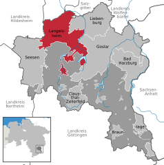
Location of Langelsheim within Goslar district  | |
| Coordinates: 51°56′17″N 10°20′06″E / 51.93806°N 10.33500°E | |
| Country | Germany |
| State | Lower Saxony |
| District | Goslar |
| Subdivisions | 8 Ortschaften |
| Government | |
| • Mayor (2021–26) | Ingo Henze[1] (SPD) |
| Area | |
| • Total | 108.77 km2 (42.00 sq mi) |
| Elevation | 204 m (669 ft) |
| Population (2022-12-31)[2] | |
| • Total | 15,043 |
| • Density | 140/km2 (360/sq mi) |
| Time zone | UTC+01:00 (CET) |
| • Summer (DST) | UTC+02:00 (CEST) |
| Postal codes | 38685 |
| Dialling codes | 05326 |
| Vehicle registration | GS |
| Website | www |
Langelsheim is a town in the district of Goslar in Lower Saxony, Germany.
Geography
[edit]The municipality is situated between the river Innerste and its tributary the river Grane, on the northern edge of the Harz mountain range and the Harz National Park, located about 8 km (5.0 mi) northwest of Goslar.
Subdivisions
[edit]Langelsheim is divided into eight Ortschaften[3] with the following population as of 30 June 2020:[4]
- Astfeld (2,097 inhabitants)
- Bredelem (438 inhabitants)
- Hahausen (765 inhabitants)
- Langelsheim (5,067 inhabitants)
- Lautenthal (1,511 inhabitants)
- Lutter am Barenberge (2,296 inhabitants)
- Wallmoden (907 inhabitants)
- Wolfshagen im Harz (2,192 inhabitants)
History
[edit]The place once called Langenizze developed in the 10th century out of a hill fort at the Kahnstein mountain, erected by the Ottonian dynasty. Langelsheim was the site of historic ironworks, first documented in the 13th century, where ore from the Mines of Rammelsberg was smelted. The former municipalities Hahausen, Lutter am Barenberge and Wallmoden are part of Langelsheim since 1 November 2021.[5]
Demographics
[edit]As of 30 June 2020 there were 11,305 inhabitants in Langelsheim.[4]

|
|
|
|

Politics
[edit]Town council
[edit]2006 local elections:
2016 local elections:
SPD: 12 FDP: 1 WGL: 6 CDU: 7
Mayors
[edit]- Since November 2013: Ingo Henze (SPD)
- 2006-2013: Henning Schrader (SPD)
International relations
[edit]Langelsheim is twinned with:
 Emmer-Compascuum, Emmen, Netherlands
 Nieuw-Weerdinge, Emmen, Netherlands
 Roswinkel, Emmen, Netherlands
Notable people
[edit]
- Henry E. Steinway, (1797-1871), born Heinrich Engelhard Steinweg in Wolfshagen in Harz, was a piano maker
- Jan Assmann, (born 1938), an Egyptologist
- Hans-Werner Bothe, (born 1952), philosopher and neurosurgeon
- Timo Rose, (born 1977), motion picture director and musician
References
[edit]- ^ "Direktwahlen in Niedersachsen vom 12. September 2021" (PDF). Landesamt für Statistik Niedersachsen. 13 October 2021.
- ^ "LSN-Online Regionaldatenbank, Tabelle A100001G: Fortschreibung des Bevölkerungsstandes, Stand 31. Dezember 2022" (in German). Landesamt für Statistik Niedersachsen.
- ^ Hauptsatzung der Stadt Langelsheim, § 4, November 2021.
- ^ a b "Einwohner der Gemeinden und Ortsteile. Stand 30.06.2020" (PDF). Landkreis - Goslar.
- ^ Gebietsänderungen vom 01. Januar bis 31. Dezember 2021, Statistisches Bundesamt


