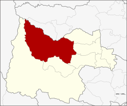
Lan Sak district
Lan Sak
ลานสัก | |
|---|---|
 View of Rabam | |
 District location in Uthai Thani province | |
| Coordinates: 15°27′10″N 99°34′34″E / 15.45278°N 99.57611°E | |
| Country | Thailand |
| Province | Uthai Thani |
| Seat | Lan Sak |
| Area | |
| • Total | 1,080.4 km2 (417.1 sq mi) |
| Population (2005) | |
| • Total | 57,548 |
| • Density | 53.3/km2 (138/sq mi) |
| Time zone | UTC+7 (ICT) |
| Postal code | 61160 |
| Geocode | 6107 |
Lan Sak (Thai: ลานสัก, pronounced [lāːn sàk]) is a district (amphoe) in northern Uthai Thani province, northern Thailand.
History
[edit]Tambons Lan Sak and Pradu Yuen of Ban Rai district were combined as a minor district (king amphoe) on 15 October 1975.[1] The minor district office was in Ban Pak Muean. It was upgraded to a full district on 13 July 1981.[2] At the same time, the office was moved to Ban Kao.
Geography
[edit]Neighboring districts are (from the east clockwise) Sawang Arom, Thap Than, Nong Chang, Huai Khot, and Ban Rai of Uthai Thani Province; Mae Poen and Chum Ta Bong of Nakhon Sawan province.
The important water resources are the Huai Thap Salao reservoir and Kha Khaeng River (Huai Kha Khaeng).
Administration
[edit]The district is divided into six sub-districts (tambons), which are further subdivided into 81 villages (mubans). The township (thesaban tambon) Lan Sak covers parts of tambons Lan Sak and Pradu Yuen. There are a further six tambon administrative organizations (TAO).
| No. | Name | Thai name | Villages | Pop. | |
|---|---|---|---|---|---|
| 1. | Lan Sak | ลานสัก | 10 | 13,905 | |
| 2. | Pradu Yuen | ประดู่ยืน | 12 | 6,697 | |
| 3. | Pa O | ป่าอ้อ | 10 | 7,358 | |
| 4. | Rabam | ระบำ | 19 | 12,573 | |
| 5. | Nam Rop | น้ำรอบ | 18 | 9,635 | |
| 6. | Thung Na Ngam | ทุ่งนางาม | 12 | 7,380 |
Nature
[edit]Hup Pa Tat is a broad valley located in the north of Uthai Thani Province.
References
[edit]- ^ ประกาศกระทรวงมหาดไทย เรื่อง แบ่งท้องที่อำเภอบ้านไร่ จังหวัดอุทัยธานี ตั้งเป็นกิ่งอำเภอลานสัก (PDF). Royal Gazette (in Thai). 92 (213 ง): 2624. 14 October 1975. Archived from the original (PDF) on 4 May 2012.
- ^ พระราชกฤษฎีกาตั้งอำเภอหนองใหญ่ อำเภอบ่อไร่ อำเภอพรหมคีรี อำเภอนาบอน อำเภอบางสะพานน้อย อำเภอนาดี อำเภอกงหรา อำเภอวังทรายพูน อำเภอธารโต อำเภอคำตากล้า อำเภอศรีนคร อำเภอด่านช้าง อำเภอพรเจริญ อำเภอวังสามหมอ และอำเภอลานสัก พ.ศ. ๒๕๒๔ (PDF). Royal Gazette (in Thai). 98 (115 ก Special): 7–10. 13 July 1981. Archived from the original (PDF) on 30 September 2007.
External links
[edit]
