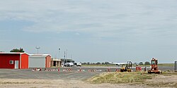
Lamar Municipal Airport (Colorado)
Southeast Colorado Regional Airport | |||||||||||||||
|---|---|---|---|---|---|---|---|---|---|---|---|---|---|---|---|
 | |||||||||||||||
| Summary | |||||||||||||||
| Airport type | Public | ||||||||||||||
| Owner | City of Lamar | ||||||||||||||
| Serves | Lamar, Colorado | ||||||||||||||
| Elevation AMSL | 3,706 ft / 1,130 m | ||||||||||||||
| Coordinates | 38°04′11″N 102°41′19″W / 38.06972°N 102.68861°W | ||||||||||||||
| Website | www.ci.lamar.co.us/... | ||||||||||||||
| Map | |||||||||||||||
 | |||||||||||||||
| Runways | |||||||||||||||
| |||||||||||||||
| Statistics (2010) | |||||||||||||||
| |||||||||||||||
Southeast Colorado Regional Airport (formerly known as the Lamar Municipal Airport) (IATA: LAA, ICAO: KLAA, FAA LID: LAA) is in Prowers County, Colorado, three miles southwest of Lamar, which owns it.[1] The National Plan of Integrated Airport Systems for 2011–2015 called it a general aviation facility.[2]
Airline flights (Central DC-3s) started about 1957; commuter airlines replaced successor Frontier in 1976-77.[citation needed]
Facilities
[edit]The airport covers 557 acres (225 ha) at an elevation of 3,706 feet (1,130 m). It has two runways: 18/36 is 6,304 by 100 feet (1,921 x 30 m) concrete and 8/26 is 5,001 by 60 feet (1,524 x 18 m) asphalt.[1]
In 2010 the airport had 13,508 aircraft operations, average 37 per day: 65% general aviation, 26% air taxi, and 9% military. 33 aircraft were then based at this airport: 73% single-engine, 24% multi-engine, and 3% jet.[1]
See also
[edit]References
[edit]- ^ a b c d FAA Airport Form 5010 for LAA PDF. Federal Aviation Administration. Effective November 15, 2012.
- ^ "2011–2015 NPIAS Report, Appendix A" (PDF). National Plan of Integrated Airport Systems. Federal Aviation Administration. October 4, 2010. Archived from the original (PDF, 2.03 MB) on September 27, 2012.
External links
[edit]- Airport page at City of Lamar website
- Lamar Municipal Airport (LAA) at Colorado DOT Airport Directory
- FAA Terminal Procedures for LAA, effective October 31, 2024
- Resources for this airport:
- FAA airport information for LAA
- AirNav airport information for KLAA
- ASN accident history for LAA
- FlightAware airport information and live flight tracker
- NOAA/NWS weather observations: current, past three days
- SkyVector aeronautical chart, Terminal Procedures

