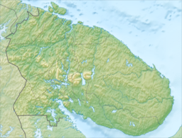
Lake Vyalozero
Appearance
| Lake Vyalozero | |
|---|---|
 from space | |
| Location | Kola Peninsula, Murmansk Oblast |
| Coordinates | 66°50′23″N 35°10′22″E / 66.8397222°N 35.1727778°E |
| Primary outflows | Vyala River |
| Basin countries | Russia |
| Surface area | 98.6 km2 (38.1 sq mi) |
| Water volume | 0.8 km3 (0.19 cu mi)[1] |
| Surface elevation | 116 m (381 ft) |
Lake Vyalozero (Russian: Вялозеро) is a large freshwater lake on the Kola Peninsula, Murmansk Oblast, Russia. The lake is mesotropic, with a slower water exchange than the neighboring Lake Inari.[2] It has an area of 98.6 km². Vyala River, a tributary of the Umba, flows from the lake.
Ecology
[edit]Along with other lakes in northwestern Russia, Lake Vyalozero was in the path of airborne radiation following the Chernobyl disaster. In 1998, 12 years after the Chernobyl disaster, Lake Vyalozero contained 1.8 times the amount of Cesium-137 compared to Lake Inari.
Some paleoglaciologists have suggested that the Lake Vyalozero-Munozero was the western extent of the Fenno-Scandian ice sheet, though this has been disputed.[3]
References
[edit]- ^ Bakunov, N. A.; Bolshiyanov, D. Yu.; Makarov, A. S.; Fedorov, G. B. (2010-05-01). "Problems in predicting 137Cs levels in lake waters of eastern Fennoscandia". Russian Journal of Ecology. 41 (3): 225–228. doi:10.1134/S1067413610030057. ISSN 1608-3334. S2CID 10881163.
- ^ Bakunov, N. A.; Bol’shiyanov, D. Yu.; Pravkin, S. A. (2021-05-01). "Reproduction of Lake Water Purification from Chernobyl 137Сs in Eastern Fennoscandia". Water Resources. 48 (3): 397–403. doi:10.1134/S0097807821030040. ISSN 1608-344X. S2CID 235173731.
- ^ Hāttestrand, Clas; Kolka, Vasili; Stroeven, Arjen P. (November 2007). "The Keiva ice marginal zone on the Kola Peninsula, northwest Russia: a key component for reconstructing the palaeoglaciology of the northeastern Fennoscandian Ice Sheet". Boreas. 36 (4): 352–370. doi:10.1080/03009480701317488. S2CID 129024536.


