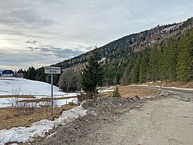
Lahn Saddle
Appearance
| Lahn Saddle Lahnsattel | |
|---|---|
 Summit of the pass | |
| Elevation | 1,006 m (3,301 ft) |
| Traversed by | Federal Highway B 23 |
| Location | Austria |
| Range | Alps |
| Coordinates | 47°35′30″N 15°29′10″E / 47.59167°N 15.48611°E |
The Lahn Saddle (German: Lahnsattel) (el. 1,006 m [3,301 ft]) is a high mountain pass in the Austrian Alps between the Bundesländer of Lower Austria and Styria.
It is traversed by Federal Highway B 23.
It connects the Salza river valley from Mariazell with the Mürz river valley.
The southeast side has a maximum grade of 11 percent. The west side from Terz im Halltal has a maximum grade of 17 percent. Three kilometres (1.9 mi) away is the peak of the Göller massif (1,766 m [5,794 ft]), with the Wildalpe in the south.
The town of Lahnsattel (1 kilometre [0.62 mi] east of the pass) has lost one fifth of its population in recent times.
See also
[edit]

