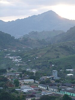
La Unión, Lempira
This article needs additional citations for verification. (January 2023) |
La Unión | |
|---|---|
Municipality | |
 La Unión | |
| Coordinates: 14°49′N 88°24′W / 14.817°N 88.400°W | |
| Country | |
| Department | Lempira |
| Municipality since | 3 May 1916 |
| Area | |
• Total | 84 km2 (32 sq mi) |
| Population (2015) | |
• Total | 13,319 |
| • Density | 160/km2 (410/sq mi) |
| Climate | Aw |
La Unión is a municipality in the Honduran department of Lempira.
It is one of the smallest municipalities of the Lempira department; travel to La Unión is a challenge. One way is to go 75 km from Gracias city on the common road for La Iguala and San Rafael, about 3 km before San Rafael is a left turn. An additional 13 km must be travelled. Another way is via Santa Bárbara-El Nispero-San Jerónimo-San Rafael-La Unión; the first 3 locations are in Santa Bárbara department.
History
[edit]
Formerly La Unión was a village called "Pueblo Nuevo", in the jurisdiction of "El Conal" (currently San Rafael). The municipality was created on 3 May 1916.[citation needed]
Geography
[edit]This section needs additional citations for verification. (January 2023) |
La Unión is located in a plateau-like surface, guarded by dense, green mountains. Despite the apparent elevation from sea level, sub-tropical forests are present and the weather is tropical.

Boundaries
[edit]Its boundaries are:
- North : Santa Bárbara department.
- South : San Rafael and La Iguala municipalities.
- East : Santa Bárbara department.
- West : La Iguala municipality.
- Surface Extents: 84 km²
Resources
[edit]This section needs additional citations for verification. (January 2023) |
This is a very prosperous town, due to coffee in both ways of plantations and gathering. The plantations are located in "Fincas" on the surrounding high mountains and the gathering in the town. Crops of Corn and Beans are indispensable. The cattle and milk products are for local consumption. There is Abundant Life Christian School, a bilingual school in La Unión, as well as public elementaries. Electrity and mobile communications services have been recently introduced to the region since 2006. There are several small grocery stores called Pulpería. The transportation services assign more buses to Santa Bárbara than to Gracias.
Population
[edit]The majority of people is a cross-breed of Native Americans and Spanish settlers, but in recent years there has been an increase in the population of foreigners.
- Population: In 2001 La Unión had 9,800 people. According to estimates; for 2008 it's expected to have 12,759.
- Villages: 6
- Settlements: 43
Demographics
[edit]At the time of the 2013 Honduras census, La Unión municipality had a population of 12,526. Of these, 98.46% were Mestizo, 0.85% Indigenous, 0.46% White, 0.19% Black or Afro-Honduran and 0.03% others.[1]

Tourism
[edit]This section needs additional citations for verification. (January 2023) |
La Unión is certainly an amazing place to visit, it is worth all the effort to get there because the mountains around it are imposing, dense and green. It has some streets paved with rocks and a viewer, from where the visitor can enjoy a nice landscape of the whole town. There are several places with internet access.
- Local Holidays: "Divina Pastora" day; 4 March.


