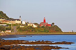
La Martre, Quebec
La Martre | |
|---|---|
 La Martre Lighthouse | |
 Location within La Haute-Gaspésie RCM | |
| Coordinates: 49°10′N 66°10′W / 49.167°N 66.167°W[1] | |
| Country | Canada |
| Province | Quebec |
| Region | Gaspésie–Îles-de-la-Madeleine |
| RCM | La Haute-Gaspésie |
| Constituted | December 18, 1923 |
| Government | |
| • Mayor | Yves Sohier |
| • Federal riding | Haute-Gaspésie—La Mitis—Matane—Matapédia |
| • Prov. riding | Gaspé |
| Area | |
| • Total | 179.11 km2 (69.15 sq mi) |
| • Land | 175.23 km2 (67.66 sq mi) |
| Population | |
| • Total | 194 |
| • Density | 1.1/km2 (3/sq mi) |
| • Pop (2016-21) | |
| • Dwellings | 119 |
| Time zone | UTC−5 (EST) |
| • Summer (DST) | UTC−4 (EDT) |
| Postal code(s) | |
| Area code(s) | 418 and 581 |
| Highways | |
| Website | www |
La Martre is a municipality in the Gaspésie-Îles-de-la-Madeleine region of the province of Quebec in Canada.
In addition to La Martre itself, the municipality also includes the communities of Cap-au-Renard, Christie, and Sainte-Marthe-de-Gaspé.[4]
History
[edit]
The area saw permanent settlement in the late 19th century and was originally called Rivière-à-la-Marthe, after the Marten River (French: Rivière à la Marthe) that flows into the Gulf of Saint Lawrence there. The marten is found along this river's banks and is abundant in the Gaspé region.[1]
In 1923, the place separated from the municipality of Sainte-Anne-des-Monts to form the Township Municipality of Christie, named in honour of Robert Christie. In 1950, the township municipality was split in two when Marsoui was incorporated as a village municipality.[5]
In 1970, the municipality was renamed to La Martre.[1]
Demographics
[edit]
In the 2021 Census of Population conducted by Statistics Canada, La Martre had a population of 194 living in 84 of its 119 total private dwellings, a change of -20.2% from its 2016 population of 243. With a land area of 175.23 km2 (67.66 sq mi), it had a population density of 1.1/km2 (2.9/sq mi) in 2021.[6]
| 2021 | 2016 | 2011 | |
|---|---|---|---|
| Population | 194 (-20.2% from 2016) | 243 (-0.8% from 2011) | 245 (-3.2% from 2006) |
| Land area | 175.23 km2 (67.66 sq mi) | 175.46 km2 (67.75 sq mi) | 173.24 km2 (66.89 sq mi) |
| Population density | 1.1/km2 (2.8/sq mi) | 1.4/km2 (3.6/sq mi) | 1.4/km2 (3.6/sq mi) |
| Median age | 55.2 (M: 57.2, F: 48.0) | 52.1 (M: 51.8, F: 53.0) | 50.2 (M: 50.2, F: 50.2) |
| Private dwellings | 119 (total) 84 (occupied) | 147 (total) 99 (occupied) | 184 (total) |
| Median household income | $.N/A | $45,184 | $.N/A |
|
|
| ||||||||||||||||||||||||||||||||||||||||||||||||||||||||||||
| Population counts are not adjusted for boundary changes. Source: Statistics Canada[12][13] | ||||||||||||||||||||||||||||||||||||||||||||||||||||||||||||||
Government
[edit]List of former mayors:[14]
- Louis Roy (1924–1926)
- Pierre Maloney (1926–1937)
- Roger L'Italien (1937–1939, 1949–1953)
- Willie Gagnon (1939–1945, 1947–1949)
- Marcellin Campion (1945–1947)
- Gérard Gagnon (1953–1957, 1958–1959)
- Damase Morin (1957–1958)
- Maurice Gasse (1959–1965)
- Grégoire Gasse (1965–1971)
- Jean-Yves Gagnon (1971–1973, 1980–1989)
- Ovilla Vallée (1973–1976, 1977–1980)
- Noël Vallée (1976–1977)
- Albert Robinson (1980)
- Jean-Guy Vallée (1989–1990)
- Fernand Hanley (1990–1992)
- Raymond St-Pierre (1992–1996, 2005–2009)
- Théodule Dion (1996–1999)
- Harold Gagnon (1999–2005)
- Claudette Robinson (2009–2013)
- Michel Laperle (2013–2014)
- Yves Sohier (2014–present)
Gallery
[edit]-
Cap-au-Renard
See also
[edit]References
[edit]- ^ a b c "La Martre (Municipalité)" (in French). Commission de toponymie du Québec. Retrieved 2011-12-19.
- ^ a b "Répertoire des municipalités: Geographic code 04030". www.mamh.gouv.qc.ca (in French). Ministère des Affaires municipales et de l'Habitation. Retrieved 2024-08-12.
- ^ a b "La Martre, Quebec (Code 2404030) Census Profile". 2021 census. Government of Canada - Statistics Canada. Retrieved 2024-08-12.
- ^ "Toponyms". Le directeur général des élections du Québec (Quebec election office). 24 August 2009. Retrieved 2010-03-11.
- ^ "Municipalité, historique" (in French). Municipalité de Marsoui. Retrieved 2011-12-16.
- ^ "Population and dwelling counts: Canada, provinces and territories, and census subdivisions (municipalities), Quebec". Statistics Canada. February 9, 2022. Retrieved October 4, 2024.
- ^ "2021 Community Profiles". 2021 Canadian census. Statistics Canada. February 4, 2022. Retrieved 2023-10-19.
- ^ "2016 Community Profiles". 2016 Canadian census. Statistics Canada. August 12, 2021. Retrieved 2022-07-14.
- ^ "2011 Community Profiles". 2011 Canadian census. Statistics Canada. March 21, 2019. Retrieved 2013-05-14.
- ^ "2006 Community Profiles". 2006 Canadian census. Statistics Canada. August 20, 2019.
- ^ "2001 Community Profiles". 2001 Canadian census. Statistics Canada. July 18, 2021.
- ^ "1971 Census of Canada - Population Census Subdivisions (Historical)". Catalogue 92-702 Vol I, part 1 (Bulletin 1.1-2). Statistics Canada: 76, 139. July 1973.
- ^ 1996, 2001, 2006, 2011, 2016, 2021 census
- ^ "Répertoire des entités géopolitiques: La Martre (municipalité) 18.12.1923 - ..." www.mairesduquebec.com. Institut généalogique Drouin. Retrieved 12 August 2024.


