Krottendorf-Gaisfeld
Appearance
Krottendorf-Gaisfeld | |
|---|---|
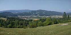
 View of the village of Krottendorf-Gaisfeld (center), Krottendorfberg (center top), and parts of Gaisfeld (right) from Muggauberg. | |
| Coordinates: 47°00′33″N 15°12′57″E / 47.00917°N 15.21583°E | |
| Country | Austria |
| State | Styria |
| District | Voitsberg |
| Government | |
| • Mayor | Johann Feichter (ÖVP) |
| Area | |
| • Total | 17.02 km2 (6.57 sq mi) |
| Population (2018-01-01)[2] | |
| • Total | 2,463 |
| • Density | 140/km2 (370/sq mi) |
| Time zone | UTC+1 (CET) |
| • Summer (DST) | UTC+2 (CEST) |
| Postal code | 8564 |
| Area code | 03143 |
| Vehicle registration | VO |
| Website | www.krottendorf-gaisfeld.at |
Krottendorf-Gaisfeld is a municipality in the district of Voitsberg in the Austrian state of Styria.
Geography
[edit]The municipality lies west of Graz.
Transport
[edit]Krottendorf-Gaisfeld has two stations, Krottendorf-Ligist and Gaisfeld, on the Köflach railway line, which runs between Graz Hauptbahnhof and Köflach. The Styria S-Bahn stops at both stations.[3]
References
[edit]- ^ "Dauersiedlungsraum der Gemeinden Politischen Bezirke und Bundesländer - Gebietsstand 1.1.2018". Statistics Austria. Retrieved 10 March 2019.
- ^ "Einwohnerzahl 1.1.2018 nach Gemeinden mit Status, Gebietsstand 1.1.2018". Statistics Austria. Retrieved 9 March 2019.
- ^ Eisenbahnatlas Österreich [Austrian railway atlas] (in German) (3rd ed.). Cologne: Schweers + Wall. 2021. p. 82. ISBN 978-3-89494-150-5.
External links
[edit] Media related to Krottendorf-Gaisfeld at Wikimedia Commons
- Official website


