Krhová
Krhová | |
|---|---|
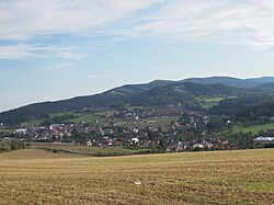
 View from the west | |
| Coordinates: 49°29′30″N 18°0′1″E / 49.49167°N 18.00028°E | |
| Country | |
| Region | Zlín |
| District | Vsetín |
| First mentioned | 1442 |
| Area | |
• Total | 8.05 km2 (3.11 sq mi) |
| Elevation | 312 m (1,024 ft) |
| Population (2024-01-01)[1] | |
• Total | 2,099 |
| • Density | 260/km2 (680/sq mi) |
| Time zone | UTC+1 (CET) |
| • Summer (DST) | UTC+2 (CEST) |
| Postal code | 756 63 |
| Website | www |
Krhová (German: Krhowa) is a municipality and village in Vsetín District in the Zlín Region of the Czech Republic. It has about 2,100 inhabitants.
Geography
[edit]Krhová is located about 16 kilometres (10 mi) north of Vsetín and 39 km (24 mi) southwest of Ostrava. The southern part of the municipality lies in the Rožnov Furrow valley and the northern part lies in the Moravian-Silesian Beskids mountain range. The highest point is at 635 m (2,083 ft) above sea level. The stream Srní potok flows through the municipality.
History
[edit]The first written mention of Krhová is from 1442.[2]
Krhová was an administrative part of the town of Valašské Meziříčí until a vote to separate the village was held on 21 April 2012, in which the majority voted in favor. On 1 January 2013, Krhová officially became an independent municipality.[3]
Demographics
[edit]
|
|
| ||||||||||||||||||||||||||||||||||||||||||||||||||||||
| Source: Censuses[4][5] | ||||||||||||||||||||||||||||||||||||||||||||||||||||||||
Transport
[edit]The I/35 road (part of the European route E442) from Valašské Meziříčí to the Czech-Slovak border in Bílá runs along the southern municipal border. The I/57 road (the section from Vsetín to Nový Jičín) runs along the western municipal border.
Krhová is located on the railway line Rožnov pod Radhoštěm–Kojetín.[6]
Sights
[edit]
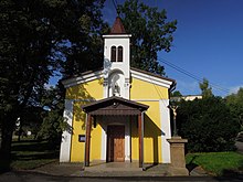
Krhová is poor in monuments. The only protected cultural monument is a wooden carved crucifix from 1837.[7] The main landmark of Krhová is the Chapel of Saints Cyril and Methodius.
References
[edit]- ^ "Population of Municipalities – 1 January 2024". Czech Statistical Office. 2024-05-17.
- ^ "Menu: Historie" (in Czech). Obec Krhová. Retrieved 2020-10-26.
- ^ "Menu: O obci" (in Czech). Obec Krhová. Retrieved 2020-10-26.
- ^ "Historický lexikon obcí České republiky 1869–2011" (in Czech). Czech Statistical Office. 2015-12-21.
- ^ "Population Census 2021: Population by sex". Public Database. Czech Statistical Office. 2021-03-27.
- ^ "Detail stanice Krhová" (in Czech). České dráhy. Retrieved 2024-05-10.
- ^ "Výsledky vyhledávání: Kulturní památky, obec Krhová". Ústřední seznam kulturních památek (in Czech). National Heritage Institute. Retrieved 2024-07-23.


