Králíky (Hradec Králové District)
Králíky | |
|---|---|
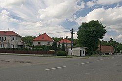
 Crossroads in the centre of Králíky | |
| Coordinates: 50°15′34″N 15°32′12″E / 50.25944°N 15.53667°E | |
| Country | |
| Region | Hradec Králové |
| District | Hradec Králové |
| First mentioned | 1635 |
| Area | |
| • Total | 9.70 km2 (3.75 sq mi) |
| Elevation | 235 m (771 ft) |
| Population (2024-01-01)[1] | |
| • Total | 399 |
| • Density | 41/km2 (110/sq mi) |
| Time zone | UTC+1 (CET) |
| • Summer (DST) | UTC+2 (CEST) |
| Postal codes | 503 15, 504 01 |
| Website | ou |
Králíky is a municipality and village in Hradec Králové District in the Hradec Králové Region of the Czech Republic. It has about 400 inhabitants.
Administrative parts
[edit]
The villages of Chmelovice, Podoliby and Řehoty are administrative parts of Králíky.
Geography
[edit]Králíky is located about 20 kilometres (12 mi) west of Hradec Králové. It lies in a flat agricultural landscape of the East Elbe Table. The brook Králický potok flows through the municipality.
History
[edit]The first written mention of Králíky is from 1635, when it was called Kralice. The village was established in the 16th century, but was devastated. In 1654, it was formed by 13 cottages. It was restored in 1686 when it was acquired by Břevnov Monastery and resettled by Germans.[2]
Řehoty could have been established in the 11th or 12th century. The first written mention of Řehoty is from 1549, when it was sold by the Pernštejn family to the town of Nový Bydžov. In 1623, the village was desolate and the land was annexed to Prasek. In 1786, three families came and founded a new settlement.[2]
The first written mention of Podoliby is from 1363. There were only two homesteads and nine cottages until 1654. It belonged to Havel Zvířetický of Wartenberg who sold the town of Nový Bydžov, including the attached villages, to Vilém II of Pernštejn. Later it was in possession of Kryštof Erazim Sommerfeld, who sold Podoliby in 1623 to Albrecht von Wallenstein. The village was destroyed during the Thirty Years' War, but it did not cease to exist. It expanded again in the 18th century and a school was built there in 1882.[2]
Chmelovice was founded in 1786. Four years later, there were already 11 houses. In 1835 there lived 93 inhabitants.[2]
Chmelovice and Podoliby were separate municipalities until 1961, when they were joined to Králíky. Řehoty was a part of Prasek until 1980, since 1 March 1980 it has been a part of Králíky.[3]
Demographics
[edit]
|
|
| ||||||||||||||||||||||||||||||||||||||||||||||||||||||
| Source: Censuses[4][5] | ||||||||||||||||||||||||||||||||||||||||||||||||||||||||
Transport
[edit]There are no railways or major roads passing through the municipality.
Sights
[edit]Králíky is poor in monuments. The only protected cultural monument is the former manor house in Chmelovice. Its present appearance is the result of the Empire style reconstruction in the 19th century.[6]
References
[edit]- ^ "Population of Municipalities – 1 January 2024". Czech Statistical Office. 2024-05-17.
- ^ a b c d "Králíky a přilehlé obce – podrobně" (in Czech). Obec Králíky. 2008-07-29. Retrieved 2022-04-06.
- ^ "Historický lexikon obcí České republiky 1869–2011: Abecední přehled obcí a částí obcí" (PDF) (in Czech). Czech Statistical Office. 2015-12-21. pp. 187, 437, 495.
- ^ "Historický lexikon obcí České republiky 1869–2011" (in Czech). Czech Statistical Office. 2015-12-21.
- ^ "Population Census 2021: Population by sex". Public Database. Czech Statistical Office. 2021-03-27.
- ^ "Výsledky vyhledávání: Kulturní památky, obec Králíky". Ústřední seznam kulturních památek (in Czech). National Heritage Institute. Retrieved 2024-07-10.

