Koh-e Hindukush
Appearance
This article needs additional citations for verification. (September 2020) |
| Koh-e Hindukush | |
|---|---|
| (Dari: کوه هندوکش) | |
| Highest point | |
| Elevation | 4,150 m (13,620 ft) |
| Parent peak | Hindu Kush |
| Coordinates | 35°24′2.1″N 69°9′32.4″E / 35.400583°N 69.159000°E |
| Geography | |
| Location | Parwan Province |
| Parent range | Hindu Kush |
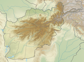
Koh-e Hindukush (Dari: کوه هندوکش "mountain which attracts the Hindu or Hindu-happy"). It is a mountain of the Hindu Kush in Afghanistan. It is located in Parwan Province.
Koh-e Hindukush lies from northeast to southwest of Afghanistan and divides the Amu Darya valley into northern and southern parts.[1]
The highest peak of Koh-e Hindukush is Mount Tirich Mir, (7,690 meters). near the border with Pakistan.[2]
References
[edit]- ^ "Hindu Kush | mountains, Asia". Encyclopedia Britannica. Retrieved 2020-06-06.
- ^ "Hindu Kush | mountains, Asia". Encyclopedia Britannica. Retrieved 2020-05-12.


