Körösszakál
Appearance
(Redirected from Koeroesszakal)
Körösszakál
Săcal | |
|---|---|
 | |
| Country | |
| County | Hajdú-Bihar |
| Area | |
| • Total | 15.02 km2 (5.80 sq mi) |
| Population (2015) | |
| • Total | 833[1] |
| • Density | 55.6/km2 (144/sq mi) |
| Time zone | UTC+1 (CET) |
| • Summer (DST) | UTC+2 (CEST) |
| Postal code | 4136 |
| Area code | 54 |

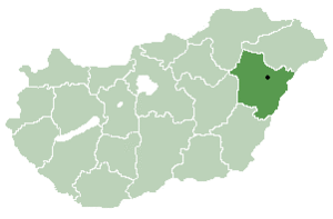
Körösszakál (Romanian: Săcal) is a village in Hajdú-Bihar county, in the Northern Great Plain region of eastern Hungary. The village is situated along the bank of the Crișul Repede.
Geography
[edit]It covers an area of 15.02 km2 (6 sq mi) and has a population of 833 people (2015).[1]
References
[edit]- ^ a b Gazetteer of Hungary, 1 January 2015. Hungarian Central Statistical Office. 3 September 2015
47°01′N 21°36′E / 47.017°N 21.600°E


