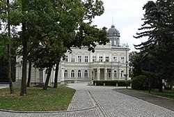
Kościelec, Koło County
Kościelec | |
|---|---|
Village | |
 Kościelec Palace | |
| Coordinates: 52°10′28″N 18°34′12″E / 52.17444°N 18.57000°E | |
| Country | |
| Voivodeship | Greater Poland |
| County | Koło |
| Gmina | Kościelec |
| Population | |
| • Total | 1,300 |
| Time zone | UTC+1 (CET) |
| • Summer (DST) | UTC+2 (CEST) |
| Vehicle registration | PKL |
| National road | |
| Voivodeship road | |
Kościelec [kɔɕˈt͡ɕɛlɛt͡s] is a village in Koło County, Greater Poland Voivodeship, in central Poland. It is the seat of the gmina (administrative district) called Gmina Kościelec.[1] It lies approximately 6 kilometres (4 mi) south-west of Koło and 116 km (72 mi) east of the regional capital Poznań.
History
[edit]
As part of the region of Greater Poland, i.e. the cradle of the Polish state, the area formed part of Poland since its establishment in the 10th century. Kościelec was a royal village of the Kingdom of Poland, administratively located in the Konin County in the Kalisz Voivodeship in the Greater Poland Province.[2]
In 1827, it had a population of 285.[3]
During the German invasion of Poland which started World War II, on September 14, 1939, German troops carried out a massacre of a group of hiding Poles (see Nazi crimes against the Polish nation).[4]
References
[edit]- ^ "Central Statistical Office (GUS) - TERYT (National Register of Territorial Land Apportionment Journal)" (in Polish). 2008-06-01.
- ^ Atlas historyczny Polski. Wielkopolska w drugiej połowie XVI wieku. Część I. Mapy, plany (in Polish). Warszawa: Instytut Historii Polskiej Akademii Nauk. 2017. p. 1b.
- ^ Słownik geograficzny Królestwa Polskiego i innych krajów słowiańskich, Tom IV (in Polish). Warszawa. 1883. p. 446.
{{cite book}}: CS1 maint: location missing publisher (link) - ^ Wardzyńska, Maria (2009). Był rok 1939. Operacja niemieckiej policji bezpieczeństwa w Polsce. Intelligenzaktion (in Polish). Warszawa: IPN. p. 95.


