Kłodnica
Appearance
(Redirected from Klodnica)
| Kłodnica River | |
|---|---|
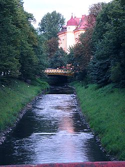
 The Kłodnica in downtown Gliwice | |
 | |
| Location | |
| Country | Poland |
| Physical characteristics | |
| Source | |
| • location | Katowice (southern district) |
| • elevation | 305 meters (1,001 ft) 165 meters (541 ft) (at mouth) |
| Mouth | |
• location | Odra river at Kędzierzyn-Koźle |
• coordinates | 50°19′47″N 18°09′44″E / 50.3297°N 18.1621°E |
| Length | 75 km (47 mi) |
| Basin size | 1,125.8 km2 (434.7 sq mi) |
| Basin features | |
| Progression | Oder→ Baltic Sea |
The Kłodnica (German: Klodnitz) is a river in the Upper Silesia region. It is about 75 km long and a right tributary of the Odra river.
Along Kłodnica's shore are Polish cities of Katowice, Kędzierzyn-Koźle, Ruda Śląska, Gliwice, and Zabrze.
There was also a Kłodnica Canal that opened in 1806. This water transport facility has been replaced by the Gliwice Canal.

