Klášterec nad Orlicí
Klášterec nad Orlicí | |
|---|---|
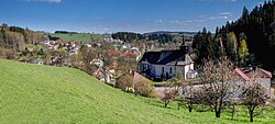
 Panorama of Klášterec nad Orlicí | |
| Coordinates: 50°6′42″N 16°33′16″E / 50.11167°N 16.55444°E | |
| Country | |
| Region | Pardubice |
| District | Ústí nad Orlicí |
| First mentioned | 1290 |
| Area | |
• Total | 17.95 km2 (6.93 sq mi) |
| Elevation | 490 m (1,610 ft) |
| Population (2024-01-01)[1] | |
• Total | 904 |
| • Density | 50/km2 (130/sq mi) |
| Time zone | UTC+1 (CET) |
| • Summer (DST) | UTC+2 (CEST) |
| Postal code | 561 82 |
| Website | www |
Klášterec nad Orlicí (German: Klösterle) is a municipality and village in Ústí nad Orlicí District in the Pardubice Region of the Czech Republic. It has about 900 inhabitants.
Administrative parts
[edit]The villages of Čihák, Jedlina, Lhotka and Zbudov are administrative parts of Klášterec nad Orlicí.
Etymology
[edit]The word klášterec is a diminutive of klášter, i.e. 'monastery'. The name refers to a small fortified monastery, which used to stand here when the village was founded.[2]
Geography
[edit]
Klášterec nad Orlicí is located about 19 kilometres (12 mi) northeast of Ústí nad Orlicí and 55 km (34 mi) east of Pardubice. It lies in the Orlické Mountains. The highest point is the hill Bučina at 677 m (2,221 ft) above sea level. The Divoká Orlice River flows through the municipality.
History
[edit]Klášterec nad Orlicí was most likely founded before 1280. The first written mention of the village is in a document of bishop Tobiáš of Bechyně from the period between 1279 and 1290, in which he praises the intention to build a monastery in this landscape. The next mention is in the bull of Pope Boniface VIII from 1295. The village was originally formed by two parts named Orlík and Orlička. The name Klášterec first appeared after 1395.[2]
Demographics
[edit]
|
|
| ||||||||||||||||||||||||||||||||||||||||||||||||||||||
| Source: Censuses[3][4] | ||||||||||||||||||||||||||||||||||||||||||||||||||||||||
Transport
[edit]There are no railways or major roads passing through the municipality.
Sights
[edit]
The Church of the Holy Trinity is a valuable example of a rural church. It was founded at the end of the 13th century and rebuilt in the late Gothic style in 1452–1453. Later it was modified in Renaissance and Baroque styles. The church complex also includes a late Baroque ossuary from 1793, an enclosure wall, and a calvary from 1799.[5]
References
[edit]- ^ "Population of Municipalities – 1 January 2024". Czech Statistical Office. 2024-05-17.
- ^ a b "Historie obce" (in Czech). Obec Klášterec nad Orlicí. Retrieved 2022-06-17.
- ^ "Historický lexikon obcí České republiky 1869–2011" (in Czech). Czech Statistical Office. 2015-12-21.
- ^ "Population Census 2021: Population by sex". Public Database. Czech Statistical Office. 2021-03-27.
- ^ "Kostel Nejsvětější Trojice" (in Czech). National Heritage Institute. Retrieved 2022-06-17.


