Kilvey Hill


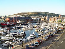
Kilvey Hill is a hill in the St. Thomas area of Swansea. It is193 metres (633 ft) high and is classed as a Sub Marilyn.[1] The top of Kilvey Hill enjoys panoramic views of Swansea city centre, Swansea Docks, Swansea Bay, ad the Lower Swansea Valley. The historic name of the hill in Welsh is Y Bigwrn, with its summit known as Pen y Bigwrn. Currently, however, it is generally known as Mynydd Cilfái.
There are a number of residential areas dotted around the base of the hill. To the north are Bon-y-maen and Pentrechwyth. To the south are Dan-y-graig, Port Tennant and St. Thomas. At the top of the hill is the TV and radio transmitter station and a telecommunications mast. The central belt of the hill consists of woodland and open grassland, which forms part of the Kilvey Community Woodland. The hill is used to host a number of mountain biking events.
Access to the top of the hill by motor vehicles is only via a steep concrete road that leads up to the summit from the village of Bon-y-maen.
Kilvey Killer
[edit]The Kilvey Killer is an annual charity endurance race, usually held in August, which involves running up and down Kilvey Hill carrying a sack of cement. The race was established in 1989 by the former amateur boxing champion and trainer Nigel Page to raise money for a special baby unit for Singleton Hospital, Swansea, which had saved his daughter Kirsty's life after she was born prematurely.[2]
References
[edit]- ^ "Kilvey Hill – By Area in the UK Mountain Database". Mountaindays.net. Archived from the original on 19 July 2011. Retrieved 12 August 2009.
- ^ [1] This Is South Wales web site "Sammy crosses The Line of Kilvey Killer" URL referred 12 March 2012
