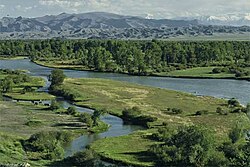
Khovd River
Appearance
| Howd River | |
|---|---|
 | |
 | |
| Native name | Ховд гол (Mongolian) |
| Location | |
| Country | Mongolia |
| Aimags | Khovd, Bayan-Ölgii |
| Major city | Khovd |
| Physical characteristics | |
| Source | glaciers |
| • location | Tavan Bogd mountain |
| Mouth | Khar-Us Lake in Great Lakes Depression |
• location | Dörgön, Khovd |
| Length | 516 km (321 mi) |
Khovd River (/ˈkɒvd/; Mongolian: Ховд гол [ˈχɔɸt ɢɔɮ]) is a river in Mongolia. It flows from Tavan Bogd mountain of the Altai Mountains to Khar-Us Lake. The length of the river is 516 kilometres.[1]
See also
[edit]References
[edit]- ^ "WWW.MEDEELEL.MN :: Танин мэдэхүй Мэдээлэл Сурталчилгааны сайт". Archived from the original on 2012-09-04. Retrieved 2012-05-11.
48°09′10″N 92°18′44″E / 48.1529°N 92.3123°E
