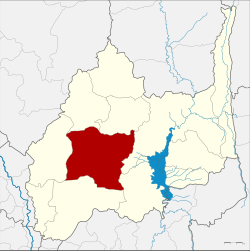
Khok Samrong district
Khok Samrong
โคกสำโรง | |
|---|---|
 District location in Lopburi province | |
| Coordinates: 15°4′11″N 100°43′26″E / 15.06972°N 100.72389°E | |
| Country | Thailand |
| Province | Lopburi |
| Area | |
• Total | 982.5 km2 (379.3 sq mi) |
| Population (2000) | |
• Total | 86,381 |
| • Density | 87.9/km2 (228/sq mi) |
| Time zone | UTC+7 (ICT) |
| Postal code | 15120 |
| Geocode | 1603 |
Khok Samrong (Thai: โคกสำโรง, pronounced [kʰôːk sǎm.rōːŋ]) is a district (amphoe) of Lopburi province in central Thailand. The district is the transportation hub of the province. Kasetsart University's Lopburi campus is in Tambon Phaniat, Khok Samrong District.
History
[edit]Originally named Phu Kha, the minor district (king amphoe) was renamed Sa Bot in 1909. In 1915 it became a full district and renamed Khok Samrong, as the district office was relocated there.
Geography
[edit]Neighbouring districts are (from the north clockwise) Nong Muang, Sa Bot, Chai Badan, Phatthana Nikhom, Mueang Lopburi and Ban Mi.
Administration
[edit]The district is divided into 13 sub-districts (tambons), which are further subdivided into 137 villages (mubans). The township (thesaban tambon) Khok Samrong covers parts of the tambon Khok Samrong. There are a further 13 tambon administrative organizations (TAO).
| 1. | Khok Samrong | โคกสำโรง | |
| 2. | Ko Kaeo | เกาะแก้ว | |
| 3. | Thalung Lek | ถลุงเหล็ก | |
| 4. | Lum Khao | หลุมข้าว | |
| 5. | Huai Pong | ห้วยโป่ง | |
| 6. | Khlong Ket | คลองเกตุ | |
| 7. | Sakae Rap | สะแกราบ | |
| 8. | Phaniat | เพนียด | |
| 9. | Wang Phloeng | วังเพลิง | |
| 10. | Dong Marum | ดงมะรุม | |
| 18. | Wang Khon Khwang | วังขอนขว้าง | |
| 20. | Wang Chan | วังจั่น | |
| 22. | Nong Khaem | หนองแขม |
Missing numbers are tambon which now form Nong Muang and Khok Charoen Districts.

