Kelsale
This article needs additional citations for verification. (September 2014) |
| Kelsale | |
|---|---|
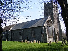
 Kelsale, Church of St Mary and St Peter | |
Location within Suffolk | |
| Civil parish | |
| District | |
| Shire county | |
| Region | |
| Country | England |
| Sovereign state | United Kingdom |
| Post town | Saxmundham |
| Postcode district | IP17 |

Kelsale is a village and former civil parish, now in the parish of Kelsale cum Carlton, in the East Suffolk district, in the county of Suffolk, England. It is located approximately 1 mile north of Saxmundham town centre at the junction of the B1121 and the A12. In 1881 the civil parish had a population of 973.[1]
Notable buildings
[edit]In Kelsale village centre there is a former Guildhall built in 1495 that is now used as a training centre.
Kelsale has a primary school, Kelsale C of EVC Primary School, a Methodist Chapel and a Grade II* listed Village Hall. Situtated below the Village Hall is a very popular committee-run Social Club & Bar.
On the hill, the grade I listed Parish Church of St. Mary and St. Peter has a distinctive lych gate. Inside there is an elaborate pulpit dated before 1631 and a statue of Samuel Clouting by Thomas Thurlow of Saxmundham.[2]
References
[edit]- ^ "Population Statistics Kelsale AP/CP through time". Vision of Britain. Retrieved 28 February 2018.
- ^ Historic England. "CHURCH OF ST MARY AND ST PETER (1199020)". National Heritage List for England. Retrieved 2 April 2014.

