Kei'a
Appearance

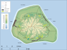
Kei'a (previously Te-apunavai) is one of the six traditional districts of the island of Mangaia, which is part of the Cook Islands archipelago.[1][2] It is located on the west side of the island, to the south of the District of Tava'enga and west of Veitatei. The district was traditionally divided into 6 tapere:[1]
- Akaoro
- Tapuata
- Tongamarama
- Te-inati
- Rupetau-i-miri
- Rupetau-i-uta
The major habitation is the village of Oneroa, which is home to over half of the island's population. The Auraka cave is also in this district.
References
[edit]- ^ a b Te Rangi Hiroa (1934). Mangaian Society. Honolulu: Bernice P. Bishop Museum. p. 126. Retrieved 9 August 2020 – via NZETC.
- ^ Allen, Bryant (1971). "Wet-Field Taro Terraces on Mangaia, Cook Islands". Journal of the Polynesian Society. 80 (3): 371–378. ISSN 0032-4000. JSTOR 20704790 – via JSTOR.
21°55′S 157°58′W / 21.917°S 157.967°W
