Keblov
Keblov | |
|---|---|
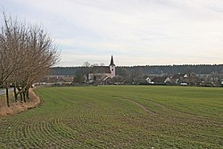
 View from the north | |
| Coordinates: 49°40′40″N 15°4′19″E / 49.67778°N 15.07194°E | |
| Country | |
| Region | Central Bohemian |
| District | Benešov |
| First mentioned | 1290 |
| Area | |
• Total | 7.11 km2 (2.75 sq mi) |
| Elevation | 436 m (1,430 ft) |
| Population (2024-01-01)[1] | |
• Total | 188 |
| • Density | 26/km2 (68/sq mi) |
| Time zone | UTC+1 (CET) |
| • Summer (DST) | UTC+2 (CEST) |
| Postal code | 257 65 |
| Website | www |
Keblov is a municipality and village in Benešov District in the Central Bohemian Region of the Czech Republic. It has about 200 inhabitants.
Administrative parts
[edit]The village of Sedlice is an administrative part of Keblov.
Geography
[edit]Keblov is located about 30 kilometres (19 mi) southeast of Benešov. It lies in the Vlašim Uplands. The highest point is the hill Hůrka at 459 m (1,506 ft) above sea level. The municipal territory is situated on the shores of the Švihov and Němčice reservoirs.
History
[edit]The first written mention of Keblov is from 1290, when it was a property of the Prague bishops. In 1436, it was acquired by the Trčka of Lípa noble family. After they sold the village in 1547, its owners changed frequently. In the 17th century, the village of Sedlice was annexed to Keblov. In 1703, Keblov was bought by Count John Leopold of Trautson and Falkenstein, who annexed the village to the Křivsoudov estate.[2][3]
Demographics
[edit]
|
|
| ||||||||||||||||||||||||||||||||||||||||||||||||||||||
| Source: Censuses[4][5] | ||||||||||||||||||||||||||||||||||||||||||||||||||||||||
Transport
[edit]There are no railways or major roads passing through the municipality. The D1 motorway runs along the northern municipal border just outside the municipal territory.
Sights
[edit]
The main landmark of Keblov is the parish Church of the Assumption of the Virgin Mary. The Gothic church is as old as the village. It was destroyed by a fire in 1895 and rebuilt in 1897.[3]
References
[edit]- ^ "Population of Municipalities – 1 January 2024". Czech Statistical Office. 2024-05-17.
- ^ "Historie obce" (in Czech). Obec Keblov. Retrieved 2022-05-24.
- ^ a b "O obci" (in Czech). Obec Keblov. Retrieved 2022-05-24.
- ^ "Historický lexikon obcí České republiky 1869–2011" (in Czech). Czech Statistical Office. 2015-12-21.
- ^ "Population Census 2021: Population by sex". Public Database. Czech Statistical Office. 2021-03-27.


