Kavea
Appearance

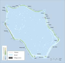
Kavea is an islet in Penrhyn Atoll (Tongareva) in the Cook Islands, in the South Pacific Ocean.[1] It is on the eastern edge of the atoll, between Temata and Pokerekere Islet. Kavea was once inhabited and contains a marae, Mahora-kura.[2]
References
[edit]- ^ Liu Chuang; Shi Ruixiang; Chen Lijun (January 2019). "Penrhyn Atoll". Institute of Geographical Sciences and Natural Resources Research, Chinese Academy of Sciences. Retrieved 10 August 2020.
- ^ Te Rangi Hiroa (April 1932). Ethnology of Tongareva. Honolulu: Bernice P. Bishop Museum. pp. 163–164. Retrieved 21 August 2020 – via NZETC.
9°4′55.86″S 157°55′32.29″W / 9.0821833°S 157.9256361°W
