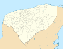
Kaua, Yucatán
Appearance
Kaua | |
|---|---|
 | |
| Coordinates: 20°37′09″N 88°24′56″W / 20.61917°N 88.41556°W | |
| Country | Mexico |
| Mexican States | Yucatán |
| Municipalities | Kaua Municipality |
| Elevation | 26 m (85 ft) |
| Population (2020) | 2,879 |
| [1] | |
| Time zone | UTC−6 (CST) |
| • Summer (DST) | UTC−5 (CDT) |
| Postal code | 97764[2] |
| Area code | 985[3] |
Kaua is a locality and the municipal seat of the eponymous Kaua Municipality in the state of Yucatán in southeastern Mexico. It is located roughly 16 kilometres (9.9 mi) southwest of the city of Valladolid
Toponymy
[edit]The name (Kaua) is a word from the Yucatec Maya language meaning the place that is bitter.
References
[edit]- ^ "Ubicación de Kauá". PueblosAmerica. Retrieved 13 December 2021.
- ^ MapasCarreteras.com.mx. "Ticul > Yucatán - Mapas, Poblaciones, Códigos Postales, Clima, Ubicación". Archived from the original on 4 March 2016. Retrieved 18 April 2010.
- ^ Telmex. "Claves LADA". Archived from the original on 14 April 2010. Retrieved 18 April 2010.

