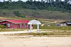
Kato, Guyana
Kato | |
|---|---|
Village | |
 | |
| Coordinates: 4°39′18″N 59°49′22″W / 4.6551°N 59.8227°W | |
| Country | |
| Region | Potaro-Siparuni |
| Government | |
| • Toshao | Clifton Ferreira[1] |
| Area | |
• Total | 250 km2 (97 sq mi) |
| Population (2012)[3] | |
• Total | 424 |
Kato is an indigenous village in the Potaro-Siparuni Region of Guyana. The village is mainly inhabited by Patamona people. The village is located in the Pacaraima Mountains.[4]
Overview
[edit]The economy of the village is based on farming[2] and gathering semi precious stones which are turned into jewelry at the Monkey Mountain lapidary.[5]
The village has a primary and a secondary school.[1] Kato has access to internet.[6] The nearest hospital is located in Mahdia which can only be accessed by plane.[7] A hydroelectric plant is under construction on the waterfalls of the nearby Chiung River and will provide electricity for Kato and neighbouring Paramakatoi.[8][9]
Transport
[edit]There is an unpaved road between Karasabai and Kato.[10] Kato is served by Kato Airport.[11]
References
[edit]- ^ a b "Kato Secondary School finally commissioned". Department of Public Information. Retrieved 2 December 2021.
- ^ a b "Stranger in Kato". Guyana Chronicle. 1 November 2015. Retrieved 2 December 2021.
- ^ "2012 Population by Village". Statistics Guyana. Retrieved 2 December 2021.
- ^ "106-year- old Patamona mother honoured by her community". Kaieteur News. 2 April 2012. Retrieved 2 December 2021.
- ^ "$10M lapidary for Monkey Mountain on stream". Department of Public Information. Retrieved 1 March 2021.
- ^ "More internet access for Region 8 communities". Department of Public Information. Retrieved 2 December 2021.
- ^ "Kato Village needs a hospital". Guyana Chronicle. 24 August 2020. Retrieved 2 December 2021.
- ^ "$450M Hydropower Plant for Kato village". Department of Public Information. 4 July 2019. Retrieved 2 December 2021.
- ^ "Kato hydro project to be completed in December". Stabroek News. 7 March 2021. Retrieved 2 December 2021.
- ^ "Orealla- Moleson Creek link among key road projects this year". Guyana Chronicle. 25 August 2019. Retrieved 2 December 2021.
- ^ "KTO - Airport". Great Circle Mapper. Retrieved 2 December 2021.
External links
[edit] Media related to Kato at Wikimedia Commons
- Kato Village Facebook page

