Karnei Shomron
Karnei Shomron
| |
|---|---|
| Hebrew transcription(s) | |
| • ISO 259 | Qarnei Šomron |
| • Also spelled | Qarne Shomron (official) |
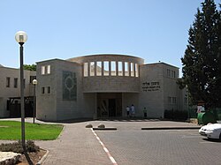
 Central Synagogue | |
| Coordinates: 32°10′18″N 35°5′52″E / 32.17167°N 35.09778°E | |
| Region | West Bank |
| District | Judea and Samaria Area |
| Founded | 1977 |
| Government | |
| • Head of Municipality | Yigal Lahav |
| Area | |
• Total | 7,179 dunams (7.179 km2 or 2.772 sq mi) |
| Population (2022)[1] | |
• Total | 9,920 |
| • Density | 1,400/km2 (3,600/sq mi) |
| Website | www.karneishomron.co.il |

Karnei Shomron (Hebrew: קַרְנֵי שׁוֹמְרוֹן, lit. "Rays (of light) of Samaria") is an Israeli settlement organized as a local council established in 1977 in the West Bank, east of Kfar Saba. Karnei Shomron is located 48 kilometres (30 mi) northeast of Tel Aviv and 85 kilometres (53 mi) north of Jerusalem. In 2022 it had a population of 9,920.
The international community considers Israeli settlements in the West Bank illegal under international law, but the Israeli government disputes this.[2]
History and archaeology
Confiscation of Palestinian land
According to ARIJ, Israel confiscated land from four nearby Palestinian villages of in order to construct Karnei Shomron:
- 713 dunams from Jinsafut,[3]
- 512 dunams from Deir Istiya,[4]
- 229 dunams from Kafr Laqif,[5]
- 216 dunams from Hajjah.[6]
Local Council neighborhoods
In 1991, several Israeli settlements were merged to become a single municipality called Karnei Shomron Local Council:
- Karnei Shomron - established in 1977, 450 families
- Ginot Shomron - established in 1984, 850 families
- Neve Menachem/Neve Oramin - established in 1991, 220 families
- Alonei Shilo - established in 1999, 25 families
Also part of Karnei Shomron are:
- Mitzpe Tzvaim[citation needed]
- Midreshet Shilat, a midrasha for girls;[citation needed]
- Ramat Gil'ad[citation needed]
- Neve Aliza, a religious neighborhood of American-style homes founded by new immigrants from the United States and Canada in 1985.[citation needed]
Nature
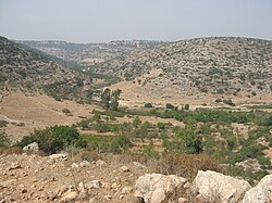
The town borders Wadi Qana, a wadi marking the border between lands that are believed to have been the territory of the tribes of Ephraim and Manasseh (Menashe) in biblical times.[7] Wadi Qana, Hebrew name: Nahal Kana, is administered by the Israel Nature and Parks Authority and is defined as a nature reserve.[8]
Leadership
The chief rabbi of Karnei Shomron is Yitzhak HaLevy.[citation needed]
Igal Lahav is the head of the Karnei Shomron Local Council.[9]
2002 mall attack
During the Second Intifada, on 16 February 2002, two people were killed and 30 people were wounded, six seriously, when a suicide bomber blew himself up at a pizzeria in Ginot Shomron shopping mall in Karnei Shomron. Rachel Thaler, 16 died of her wounds on 27 February. The Popular Front for the Liberation of Palestine (PFLP) claimed responsibility for the attack.[citation needed]
Notable residents
- Michael Ben-Ari (b. 1963), politician
- Moshe Feiglin (b. 1962), politician
- Shmuel Sackett (b. 1961), activist
References
- ^ "Regional Statistics". Israel Central Bureau of Statistics. Retrieved 21 March 2024.
- ^ "The Geneva Convention". BBC News. 10 December 2009. Retrieved 27 September 2011.
- ^ Jinsafut Village Profile (including Al Funduq Locality), ARIJ, p. 17
- ^ Deir Istiya Town Profile, ARIJ, p. 17
- ^ Kafr Laqif Village Profile, 2013, ARIJ, pp. 17-18
- ^ Hajja village profile, ARIJ, p. 17
- ^ Green and pleasant land?, 2006
- ^ "Israel Nature and Parks Authority: Nahal Kana". Israel Nature and Parks Authority.
- ^ jinn@orijinn.net, Jinn. "קרני שומרון" (in Hebrew). Retrieved 2019-07-01.

