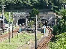
Kanmon Railway Tunnel
You can help expand this article with text translated from the corresponding article in Japanese. (October 2018) Click [show] for important translation instructions.
|
 | |
| Overview | |
|---|---|
| Line | San'yō Main Line |
| Location | Honshu–Kyushu |
| Coordinates | 33°55′18.4″N 130°55′58.2″E / 33.921778°N 130.932833°E |
| Operation | |
| Opened | 1942 |
| Operator | JR Kyushu |
| Character | Passenger and freight |
| Technical | |
| Line length | 3,604 m (11,824 ft)/ 3,614 m (11,857 ft) |
The Kanmon Railway Tunnel (関門鉄道トンネル, kanmon tetsudō tonneru) was the first undersea tunnel in Japan. It goes underneath the Kanmon Straits, connecting the islands of Honshu and Kyushu.[1] It is an important link in the Japanese rail network. Its construction began in 1936, and it was completed in November 1942, during the Pacific War. The Honshu-bound tunnel is 3,604 m (11,824 ft) long, the Kyushu-bound tunnel is 3,614 m (11,857 ft). Track gauge is 1,067 mm (3 ft 6 in) (Cape gauge), and its electric power supply is at 1,500 volts DC.
Near the end of the Pacific War the Allies planned to blow up the two tunnels with 50,000 pounds of explosives as part of the invasion of Japan. The Office of Strategic Services trained 250 of its agents for the task, but the surrender of Japan occurred before they were needed.[2]
The Kyushu Railway Company (JR Kyushu) assumed ownership of this tunnel following the breakup of the Japanese National Railways system in 1987.[citation needed]

Coordinates
[edit]- Shimonoseki entrance: 33°56′03″N 130°55′00″E / 33.934303°N 130.916556°E
- Moji entrance: 33°54′37″N 130°56′11″E / 33.910365°N 130.936472°E
See also
[edit]- Shin-Kanmon Tunnel for the high-speed railway
- Kanmon Road Tunnel
References
[edit]- ^ 第2版,世界大百科事典内言及, 日本大百科全書(ニッポニカ),ブリタニカ国際大百科事典 小項目事典,百科事典マイペディア,精選版 日本国語大辞典,旺文社日本史事典 三訂版,デジタル大辞泉,世界大百科事典. "関門トンネルとは". コトバンク (in Japanese). Retrieved 2021-08-12.
{{cite web}}: CS1 maint: multiple names: authors list (link) CS1 maint: numeric names: authors list (link) - ^ Breuer, William B. (2003). The Spy Who Spent the War in Bed: And Other Bizarre Tales from World War II. Hoboken, New Jersey: John Wiley & Sons. p. 200. ISBN 0-471-26739-2.
