Kanji Dol
Appearance
Kanji Dol | |
|---|---|
 | |
| Coordinates: 45°53′59.19″N 14°2′55.55″E / 45.8997750°N 14.0487639°E | |
| Country | |
| Traditional region | Inner Carniola |
| Statistical region | Gorizia |
| Municipality | Idrija |
| Area | |
| • Total | 3.63 km2 (1.40 sq mi) |
| Elevation | 897.3 m (2,943.9 ft) |
| Population (2015) | |
| • Total | 11 |
| • Density | 3/km2 (8/sq mi) |
| [1] | |
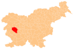
Kanji Dol (pronounced [ˈkaːnji ˈdoːu̯]; German: Kanidol[2]) is a dispersed settlement in the hills south of Črni Vrh in the Municipality of Idrija[3] in the traditional Inner Carniola region of Slovenia.[2] The settlement no longer had any permanent residents according to the 2002 census, but it has been repopulated in recent years.[1]
References
[edit]- ^ a b "Kanji Dol, Idrija". Place Names. Statistical Office of the Republic of Slovenia. Retrieved 22 October 2015.
- ^ a b Leksikon občin kraljestev in dežel zastopanih v državnem zboru, vol. 6: Kranjsko. 1906. Vienna: C. Kr. Dvorna in Državna Tiskarna, p. 124.
- ^ Idrija municipal site
External links
[edit] Media related to Kanji Dol at Wikimedia Commons
- Kanji Dol on Geopedia


