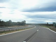
Kanfanar interchange
Appearance
| Kanfanar interchange | |
|---|---|
| Croatian: čvor Kanfanar | |
 A9 connecting to the Kanfanar interchange | |
 | |
| Location | |
| Kanfanar, Croatia | |
| Coordinates | 45°06′46″N 13°48′53″E / 45.112664°N 13.814621°E |
| Roads at junction | |
| Construction | |
| Type | Cloverleaf interchange |
The Kanfanar interchange (Croatian: Čvor Kanfanar) is a cloverleaf interchange west of Kanfanar, Croatia. The interchange represents the western terminus of the A8 motorway and it connects the A8 route to the A9 motorway representing major a link in the Croatian motorway system.[1] The interchange represents a junction of three arms of the European route E751.[2]
Construction of the interchange marked start of construction of the A9 motorway in form of an expressway. Its construction started in 1988 and finished in 1991, making it a part of the first section of the Pula–Umag route which was subsequently expanded to comprise six lanes and dual carriageways, connecting the largest tourist resorts in the western Istria to Slovenia.[3][4]
See also
[edit]References
[edit]- ^ "Pravilnik o označavanju autocesta, njihove stacionaže, brojeva izlaza i prometnih čvorišta te naziva izlaza, prometnih čvorišta i odmorišta" [Regulation on motorway markings, chainage, interchange/exit/rest area numbers and names]. Narodne novine (in Croatian). May 6, 2003. Retrieved September 6, 2010.
- ^ "European Agreement on Main International Traffic Arteries" (PDF). United Nations Economic Commission for Europe. March 13, 2008. Retrieved September 6, 2010.
- ^ "Overview of motorways and semi-motorways". HUKA. Archived from the original on July 15, 2011. Retrieved September 8, 2010.
- ^ "Istarski Y" [Istrian Y] (PDF) (in Croatian). BINA Istra. 2010. Archived from the original (PDF) on September 19, 2011. Retrieved September 14, 2011.
