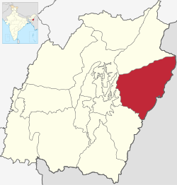
Kamjong district
Kamjong district | |
|---|---|
 Location in Manipur | |
| Coordinates (Kamjong): 24°52′N 94°30′E / 24.86°N 94.50°E | |
| Country | |
| State | Manipur |
| Established | 2016 |
| Headquarters | Kamjong |
| Area | |
• Total | 2,338 km2 (903 sq mi) |
| • Rank | 3 |
| Population (2011)[1] | |
• Total | 45,616 |
| • Density | 20/km2 (51/sq mi) |
| Language(s) | |
| • Official | Meitei (officially called Manipuri)[a][2] |
| Time zone | UTC+05:30 (IST) |
Kamjong District (Meitei pronunciation: /kām-jōng/[a]) is one of the 16 districts of Manipur, India. It was created in 2016 from the Ukhrul district, prior to which it was a subdivision of the latter.[3][4]
The district headquarters is located at Kamjong. It shares a long international border with Myanmar. The district is bounded by Myanmar in the east, Kangpokpi district in the West, Ukhrul district in the north and Tengnoupal district in the south. The terrain of the district is hilly with varying heights of 913 m to 3114 m (MSL). The district headquarter is linked with state highway of 120 Km from Imphal.
Demographics
[edit]Kamjong district has a population of 45,616, entirely rural. Kamjong had a sex ratio of 943 females per 1000 males. Scheduled Castes and Scheduled Tribes made up 0.05% and 96.56% of the population respectively.[1]
At the time of the 2011 census, 89.12% of the population spoke Tangkhul, 6.61% Thadou and 1.63% Kuki as their first language.[6]
Sub-divisions
[edit]The following are the sub-divisions in Kamjong district:
See also
[edit]Notes
[edit]- ^ a b Meitei language (officially known as Manipuri language) is the official language of Manipur. Other regional languages of different places in Manipur may either be predominantly spoken or not in their respective places but "Meitei" is always officially used.
References
[edit]- ^ a b "District Census Hand Book - Ukhrul" (PDF). Census of India. Registrar General and Census Commissioner of India.
- ^ "Report of the Commissioner for linguistic minorities: 47th report (July 2008 to June 2010)" (PDF). Commissioner for Linguistic Minorities, Ministry of Minority Affairs, Government of India. p. 78. Archived from the original (PDF) on 13 May 2012. Retrieved 16 February 2012.
- ^ Khelen Thokchom, More districts in Manipur, The Telegraph (Kolkata), 9 December 2016. ProQuest 2290178396
- ^ Esha Roy (6 December 2016). "Simply put: Seven new districts that set Manipur ablaze". Indian Express.
- ^ "Table C-01 Population by religious community: Manipur". Census of India. Registrar General and Census Commissioner of India. 2011.
- ^ a b "Table C-16 Population by mother tongue: Manipur". Census of India. Registrar General and Census Commissioner of India. 2011.
