Kalamazoo, Florida
Appearance
Kalamazoo | |
|---|---|
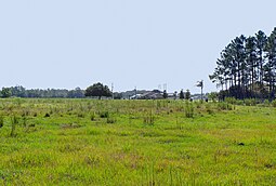
 Kalamazoo - The geographic center is on private property near the tree in center frame | |
| Coordinates: 28°50′46″N 081°06′36″W / 28.84611°N 81.11000°W | |
| Country | |
| State | |
| County | Volusia |
| Elevation | 20 ft (6 m) |
| Time zone | UTC-5 (Eastern (EST)) |
| • Summer (DST) | UTC-4 (EDT) |
| enter ZIP code | 32764 |
| Area code | 386 |
| GNIS feature ID | 294821[1] |
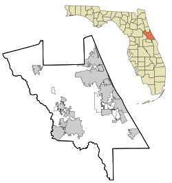
Kalamazoo is an unincorporated community located in southwest Volusia County, Florida. As of 2011, Kalamazoo is private property.
History
[edit]According to longtime area residents, Kalamazoo was named for the many people who moved there from Michigan.[2]
The name may also allude to celery farming in Kalamazoo, Michigan, for which that city was noted in the late 19th and early 20th centuries.[3] In 1908, a company was capitalized with $25,000 to develop a celery farm on 10,000 acres in Kalamazoo, Florida, following on the success of celery farming in nearby Sanford. Its president was C. F. Walker of Savannah, Georgia.[4]
References
[edit]- ^ "US Board on Geographic Names". United States Geological Survey. October 25, 2007. Retrieved January 31, 2008.
- ^ Williamson, Ronald (May 11, 2008). "Echoes of the Past - A lonely highway Offers Few Clues to Communities' Former Importance". Daytona Beach News-Journal.
- ^ Peppel, Fred (February 2005). "Stalking the Celery City". Kalamazoo Public Library. Retrieved May 17, 2012.
- ^ "New Celery Growing Colony Established". The Florida East Coast Homeseeker. 10: 87. January 1908.


