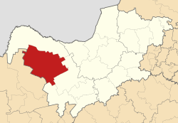
Kagisano Local Municipality
Appearance
Kagisano Local Municipality | |
|---|---|
 Location in the North West | |
| Country | South Africa |
| Province | North West |
| District | Dr Ruth Segomotsi Mompati District |
| Seat | Ganyesa |
| Area | |
• Total | 11,354 km2 (4,384 sq mi) |
| Population (2001)[1] | |
• Total | 88,780 |
| • Density | 7.8/km2 (20/sq mi) |
| Time zone | UTC+2 (SAST) |
| Municipal code | NW391 |
Kagisano Local Municipality was a local municipality in Dr Ruth Segomotsi Mompati District Municipality, North West Province, South Africa, until the election of 18 May 2011, when it was merged with the Molopo Local Municipality to form the Kagisano-Molopo Local Municipality.
Main places
[edit]The 2001 census divided the municipality into the following main places:[2]
| Place | Code | Area (km2) | Population | Most spoken language |
|---|---|---|---|---|
| Batlharo Ba Lotlhware | 61101 | 8,084.80 | 59,209 | Tswana |
| Louwna | 61103 | 0.60 | 235 | Tswana |
| Morokweng | 61104 | 1,584.86 | 26,694 | Tswana |
| Piet Plessis | 61105 | 32.09 | 1,055 | Tswana |
| Remainder of the municipality | 61102 | 4,986.07 | 9,193 | Tswana |
References
[edit]- ^ "Community Survey, 2007: Basic Results Municipalities" (PDF). Statistics South Africa. Archived from the original (PDF) on 25 August 2013. Retrieved 20 October 2009.
- ^ Lookup Tables - Statistics South Africa[permanent dead link]
26°25′S 24°0′E / 26.417°S 24.000°E

