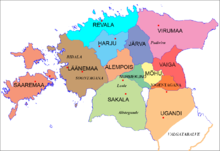
Jogentagana
Appearance
| Jogentagana | |||||||
|---|---|---|---|---|---|---|---|
| county of Ancient Estonia | |||||||
| 9th Century–1224 | |||||||
 Ancient Estonian counties | |||||||
| Area | |||||||
| • Coordinates | 58°30′N 26°30′E / 58.5°N 26.5°E | ||||||
| • Type | Council of Elders | ||||||
| History | |||||||
• Established | 9th Century | ||||||
• Livonian Crusade | 1224 | ||||||
| |||||||
Jogentagana (Latin: Jogentagania) was a small landlocked ancient Estonian county in the eastern part of the territory of Estonia. It was conquered by the Teutonic Order in the Estonian Crusade and became part of the Livonian Order.
Settlements
[edit]See also
[edit]References
[edit]External links
[edit]- Kuidas elasid inimesed vanasti, möödunud sajandil ja praegu (Estonian) Archived 2010-01-22 at the Wayback Machine
- 9. - 13. saj.pärinevad Eesti aardeleiud (Estonian)
- Eesti haldusjaotus ja võõrvõimude vaheldumine läbi aegade (Estonian)
