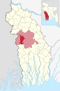
Jhikargacha Upazila
Jhikargacha
ঝিকরগাছা | |
|---|---|
 Mokamtala School is in Jhikargacha Upazila | |
 | |
| Coordinates: 23°6′N 89°8′E / 23.100°N 89.133°E | |
| Country | |
| Division | Khulna |
| District | Jessore |
| Area | |
| • Total | 307.96 km2 (118.90 sq mi) |
| Population | |
| • Total | 331,137 |
| • Density | 1,100/km2 (2,800/sq mi) |
| Time zone | UTC+6 (BST) |
| Postal code | 7420[2] |
| Area code | 04225[3] |
| Website | Official Map of Jhikargachha |
Jhikargachha (Bengali: ঝিকরগাছা) is an upazila of Jessore District in the Division of Khulna, Bangladesh.
Demographics
[edit]As of the 2011 Census of Bangladesh, Jhikargachha upazila had 72,266 households and a population of 298,908. 59,174 (19.80%) were under 10 years of age. Jhikargachha had an average literacy rate of 53.02%, compared to the national average of 51.8%, and a sex ratio of 1032 females per 1000 males. 41,439 (13.86%) of the population lived in urban areas.[5][6]
At the 1991 Bangladesh census, Jhikargachha had a population of 235,882. Males constituted 51.24% of the population and females 48.76%. The population aged 18 or older was 119,652. Jhikargachha had an average literacy rate of 27.9% (7+ years), compared to the national average of 32.4%.[7]
Administration
[edit]Jhikargacha thana was turned into an upazila in 1983.
Jhikargacha Upazila is divided into Jhikargacha Municipality and 11 union parishads: Bankra, Ganganandapur, Gadkhali, Hajirbagh, Jhikargachha, Magura, Nabharan, Nibaskhola, Panisara, Shankarpur, and Shimula. The union parishads are subdivided into 164 mauzas and 174 villages.[5]
Jhikargacha Municipality is subdivided into 9 wards and 15 mahallas.[5]
Education
[edit]According to Banglapedia, Jhikargacha B. M. High School, founded in 1936, Ganganandapur High School (1940), Jhikargachha Pilot Girls High School (1953), Jhikargacha M. L. High School (1888), and Raghunath Nagar Secondary School (1922) are notable secondary schools.[8]
See also
[edit]References
[edit]- ^ National Report (PDF). Population and Housing Census 2022. Vol. 1. Dhaka: Bangladesh Bureau of Statistics. November 2023. p. 400. ISBN 978-9844752016.
- ^ "Bangladesh Postal Code". Dhaka: Bangladesh Postal Department under the Department of Posts and Telecommunications of the Ministry of Posts, Telecommunications and Information Technology of the People's Republic of Bangladesh. 21 October 2024.
- ^ "Bangladesh Area Code". China: Chahaoba.com. 18 October 2024.
- ^ Population and Housing Census 2022 - District Report: Jashore (PDF). District Series. Dhaka: Bangladesh Bureau of Statistics. June 2024. ISBN 978-984-475-280-1.
- ^ a b c "Bangladesh Population and Housing Census 2011 Zila Report – Jessore" (PDF). bbs.gov.bd. Bangladesh Bureau of Statistics.
- ^ "Community Tables: Jhenaidah district" (PDF). bbs.gov.bd. Bangladesh Bureau of Statistics. 2011.
- ^ "Population Census Wing, BBS". Archived from the original on 2005-03-27. Retrieved November 10, 2006.
- ^ Ansari, Firoj (2012). "Jhikargachha Upazila". In Islam, Sirajul; Jamal, Ahmed A. (eds.). Banglapedia: National Encyclopedia of Bangladesh (Second ed.). Asiatic Society of Bangladesh.

