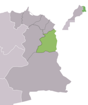
Jerada Province
Appearance
Jerada Province
إقليم جرادة | |
|---|---|
 Jerada Province, Oriental Region, Morocco | |
 | |
| Country | |
| Region | Oriental |
| Capital | Jerada |
| Population (2004) | |
| • Total | 105,840 |
Jerada (Arabic: جرادة) is a province in the Oriental Region of Morocco. Its population in 2004 was 105,840.[1]
The major cities and towns are:[2]
Subdivisions
[edit]The province is divided administratively into the following:[3]
| Name | Geographic code | Type | Households | Population (2004) | Foreign population | Moroccan population | Notes |
|---|---|---|---|---|---|---|---|
| Ain Bni Mathar | 275.01.03. | Municipality | 2519 | 13526 | 85 | 13441 | |
| Jerada | 275.01.17. | Municipality | 8120 | 43916 | 46 | 43870 | |
| Touissit | 275.01.35. | Municipality | 716 | 3429 | 9 | 3420 | |
| Gafait | 275.03.03. | Rural commune | 441 | 2654 | 1 | 2653 | |
| Guenfouda | 275.03.05. | Rural commune | 1009 | 5748 | 11 | 5737 | |
| Laaouinate | 275.03.07. | Rural commune | 628 | 3790 | 1 | 3789 | |
| Lebkhata | 275.03.09. | Rural commune | 371 | 2546 | 0 | 2546 | |
| Ras Asfour | 275.03.13. | Rural commune | 273 | 1694 | 15 | 1679 | |
| Sidi Boubker | 275.03.15. | Rural commune | 547 | 2807 | 8 | 2799 | 1942 residents live in the center, called Sidi Boubker e; 865 residents live in rural areas. |
| Tiouli | 275.03.21. | Rural commune | 1019 | 6317 | 104 | 6213 | 1997 residents live in the center, called Oued Heimer; 4320 residents live in rural areas. |
| Bni Mathar | 275.05.01. | Rural commune | 1152 | 7089 | 7 | 7082 | |
| Mrija | 275.05.11. | Rural commune | 453 | 2841 | 1 | 2840 | |
| Oulad Ghziyel | 275.05.13. | Rural commune | 819 | 6488 | 2 | 6486 | |
| Oulad Sidi Abdelhakem | 275.05.15. | Rural commune | 401 | 2995 | 18 | 2977 |
References
[edit]- ^ "World Gazetteer: Jerada - profile of geographical entity including name variants". www.world-gazetteer.com. Archived from the original on 9 February 2013. Retrieved 2 February 2022. Archived 9 February 2013 at archive.today
- ^ "World Gazetteer: Jerada - largest cities (Per geographical entity)". www.world-gazetteer.com. Archived from the original on 10 February 2013. Retrieved 2 February 2022. Archived 10 February 2013 at archive.today
- ^ "Recensement général de la population et de l'habitat de 2004" (PDF). Haut-commissariat au Plan, Lavieeco.com. Archived from the original (PDF) on 24 July 2012. Retrieved 27 April 2012. population.pdf Archived 8 April 2019 at Wikiwix
34°18′42″N 2°09′49″W / 34.31167°N 2.16361°W


